Jörn geodata
Jörn (Västerbotten) is a populated place; located in Sweden in Europe/Stockholm (GMT+2) time zone. With population of 777 people, there are 986 cities with bigger population in this country. Compared to other cities in Sweden, 95.9% of cities are located further ↓South; 94.1% of cities are located further ←West and 95.2% of cities have lower elevation than Jörn. Note1
Administrative division(s):
- Level 1: Västerbotten
- Level 2: Skellefteå Kommun
- Level 3: Jörn-Boliden
- Level 4: Jörn socken


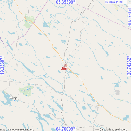
Jörn GPS coordinates[2]
65° 3' 32.904" North, 20° 2' 21.084" East
| Map corner | latitude | longitude |
|---|---|---|
| Upper-left | 65.35399°, | 19.33607° |
| Center: | 65.05914°, | 20.03919° |
| Lower-right: | 64.76099°, | 20.74232° |
| Map W x H: | 65.9×65.9 km | = 40.9×40.9mi |
| max Lat: | 67.85572° ⇑4.1% North |
| Jörn: | 65.05914° |
| min Lat: | ⇓95.9% South 55.34337° |
| min Long | Jörn | max Long |
| 11.1712° | 20.03919° | 24.13676° |
| W 94.1%⇐ | ⇒5.9% E |
Elevation
Elevation of Jörn is 267 m = 876 ft, and this is 184.4 m = 605 ft above average elevation for this country.
| Max E: |
663 m = 2175 ft | 4.8% |
| Jörn | 267 m 876 ft | |
| Avg. | 82.6 m = 271 ft | |
Min E: |
-1 m = -3 ft | 95.2% |
See also: Sweden elevation on elevation.city.
Geographical zone
Jörn is located in North temperate zone (between Tropic of Cancer and the Arctic Circle). Distance of this North polar circle is 167.3 km =104 mi to North.| Distance of | km | miles | from Jörn |
|---|---|---|---|
| North Pole | 2773.2 | 1723.2 | to North |
| Arctic Circle | 167.3 | 104 | to North |
| Tropic Cancer | 4628 | 2875.7 | to South |
| Equator | 7233.9 | 4494.9 | to South |


Nearby cities:
15 places around Jörn: (largest is in red/bold)
• Backa
49 km =30.4 mi,  99°
99°
• Boliden
26.8 km =16.7 mi,  142°
142°
• Ersmark
46.7 km =29 mi,  120°
120°
• Forsbacka
39.1 km =24.3 mi,  146°
146°
• Kåge
51 km =31.7 mi, 119°
• Långsele
28.7 km =17.8 mi,  159°
159°
• Medle
48.4 km =30.1 mi, 137°
• Norsjö
30.9 km =19.2 mi,  238°
238°
• Nyland
43.6 km =27.1 mi,  128°
128°
• Ostvik
52.1 km =32.4 mi,  112°
112°
• Skellefteå
55.1 km =34.2 mi, 128°
• Stensjön
50.5 km =31.4 mi, 99°
• Storvik
34 km =21.1 mi,  72°
72°
• Svartå
34.2 km =21.3 mi,  94°
94°
• Tällberg
36.7 km =22.8 mi, 103°
Sources, notices
• [Note1] Compared only with cities in Sweden existing in our database
• [Src1] Map data: © OpenStreetMap contributors (CC-BY-SA)
• [Src2] Other city data from geonames.org with taken over terms of usage.
• [Src3] Geographical zone / Annual Mean Temperature by Robert A. Rohde @ Wikipedia
