Zavrč geodata
Zavrč is a seat of a first-order administrative division; located in Slovenia in Europe/Ljubljana (GMT+2) time zone. With population of 77 people, there are 598 cities with bigger population in this country. Compared to other cities in Slovenia, 65.2% of cities are located further ↓South; 90.3% of cities are located further ←West and 79.3% of cities have higher elevation than Zavrč. Note1


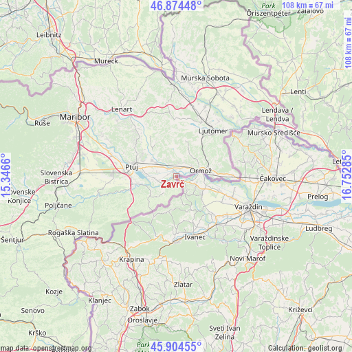
Zavrč GPS coordinates[2]
46° 23' 30.012" North, 16° 2' 58.992" East
| Map corner | latitude | longitude |
|---|---|---|
| Upper-left | 46.87448°, | 15.3466° |
| Center: | 46.39167°, | 16.04972° |
| Lower-right: | 45.90455°, | 16.75285° |
| Map W x H: | 107.8×107.8 km | = 67×67mi |
| max Lat: | 46.83694° ⇑34.8% North |
| Zavrč: | 46.39167° |
| min Lat: | ⇓65.2% South 45.47667° |
| min Long | Zavrč | max Long |
| 13.52639° | 16.04972° | 16.4975° |
| W 90.3%⇐ | ⇒9.7% E |
Elevation
Elevation of Zavrč is 202 m = 663 ft, and this is 123.6 m = 406 ft below average elevation for this country.
| Max E: |
1551 m = 5089 ft | 79.3% |
| Avg. | 325.6 m = 1068 ft | |
| Zavrč | 202 m = 663 ft | |
Min E: |
2 m = 7 ft | 20.7% |
See also: Slovenia elevation on elevation.city.
Geographical zone
Zavrč is located in North temperate zone (between Tropic of Cancer and the Arctic Circle). Distance of this North polar circle is 2242.9 km =1393.7 mi to North.| Distance of | km | miles | from Zavrč |
|---|---|---|---|
| North Pole | 4848.8 | 3012.9 | to North |
| Arctic Circle | 2242.9 | 1393.7 | to North |
| Tropic Cancer | 2552.4 | 1586 | to South |
| Equator | 5158.3 | 3205.2 | to South |


Nearby cities:
15 places around Zavrč: (largest is in red/bold)
• Bukovci
6.5 km =4 mi,  265°
265°
• Cirkulane
6.8 km =4.2 mi,  218°
218°
• Dornava
8.9 km =5.5 mi,  304°
304°
• Gorišnica
3.8 km =2.4 mi,  313°
313°
• Markovci
9.3 km =5.8 mi, 272°
• Mihovci pri Vel. Nedelji
5 km =3.1 mi,  71°
71°
• Moškanjci
5.4 km =3.4 mi, 306°
• Ormož
8.3 km =5.2 mi, 74°
• Podgorci
4.3 km =2.7 mi,  14°
14°
• Podvinci
11.2 km =7 mi,  293°
293°
• Spuhlja
10.6 km =6.6 mi,  282°
282°
• Stojnci
5.3 km =3.3 mi,  257°
257°
• Sveti Tomaž
10.6 km =6.6 mi, 14°
• Videm pri Ptuju
11.3 km =7 mi, 256°
• Zamušani
3.7 km =2.3 mi,  335°
335°
Sources, notices
• [Note1] Compared only with cities in Slovenia existing in our database
• [Src1] Map data: © OpenStreetMap contributors (CC-BY-SA)
• [Src2] Other city data from geonames.org with taken over terms of usage.
• [Src3] Geographical zone / Annual Mean Temperature by Robert A. Rohde @ Wikipedia
