Zamušani geodata
Zamušani (Gorišnica) is a populated place; located in Slovenia in Europe/Ljubljana (GMT+2) time zone. With population of 523 people, there are 523 cities with bigger population in this country. Compared to other cities in Slovenia, 71% of cities are located further ↓South; 89.7% of cities are located further ←West and 78.2% of cities have higher elevation than Zamušani. Note1


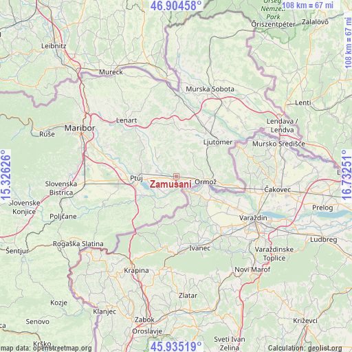
Zamušani GPS coordinates[2]
46° 25' 19.344" North, 16° 1' 45.768" East
| Map corner | latitude | longitude |
|---|---|---|
| Upper-left | 46.90458°, | 15.32626° |
| Center: | 46.42204°, | 16.02938° |
| Lower-right: | 45.93519°, | 16.73251° |
| Map W x H: | 107.8×107.8 km | = 67×67mi |
| max Lat: | 46.83694° ⇑29% North |
| Zamušani: | 46.42204° |
| min Lat: | ⇓71% South 45.47667° |
| min Long | Zamušani | max Long |
| 13.52639° | 16.02938° | 16.4975° |
| W 89.7%⇐ | ⇒10.3% E |
Elevation
Elevation of Zamušani is 212 m = 696 ft, and this is 113.6 m = 373 ft below average elevation for this country.
| Max E: |
1551 m = 5089 ft | 78.2% |
| Avg. | 325.6 m = 1068 ft | |
| Zamušani | 212 m = 696 ft | |
Min E: |
2 m = 7 ft | 21.8% |
See also: Slovenia elevation on elevation.city.
Geographical zone
Zamušani is located in North temperate zone (between Tropic of Cancer and the Arctic Circle). Distance of this North polar circle is 2239.5 km =1391.6 mi to North.| Distance of | km | miles | from Zamušani |
|---|---|---|---|
| North Pole | 4845.4 | 3010.8 | to North |
| Arctic Circle | 2239.5 | 1391.6 | to North |
| Tropic Cancer | 2555.7 | 1588 | to South |
| Equator | 5161.6 | 3207.3 | to South |


Nearby cities:
15 places around Zamušani: (largest is in red/bold)
• Bukovci
6.3 km =3.9 mi,  231°
231°
• Cirkulane
9.1 km =5.7 mi,  197°
197°
• Dornava
6 km =3.7 mi,  285°
285°
• Gorišnica
1.4 km =0.9 mi,  235°
235°
• Juršinci
8.3 km =5.2 mi,  327°
327°
• Kicar
9.6 km =6 mi, 290°
• Markovci
8.3 km =5.2 mi,  249°
249°
• Mihovci pri Vel. Nedelji
6.5 km =4 mi,  106°
106°
• Moškanjci
2.8 km =1.7 mi,  265°
265°
• Podgorci
2.7 km =1.7 mi,  73°
73°
• Podvinci
8.7 km =5.4 mi,  277°
277°
• Spuhlja
8.8 km =5.5 mi,  263°
263°
• Stojnci
5.8 km =3.6 mi,  218°
218°
• Sveti Tomaž
8.1 km =5 mi,  31°
31°
• Zavrč
3.7 km =2.3 mi,  155°
155°
Sources, notices
• [Note1] Compared only with cities in Slovenia existing in our database
• [Src1] Map data: © OpenStreetMap contributors (CC-BY-SA)
• [Src2] Other city data from geonames.org with taken over terms of usage.
• [Src3] Geographical zone / Annual Mean Temperature by Robert A. Rohde @ Wikipedia
