Markovci geodata
Markovci is a seat of a first-order administrative division; located in Slovenia in Europe/Ljubljana (GMT+2) time zone. With population of 462 people, there are 558 cities with bigger population in this country. Compared to other cities in Slovenia, 66.2% of cities are located further ↓South; 87.3% of cities are located further ←West and 75.8% of cities have higher elevation than Markovci. Note1


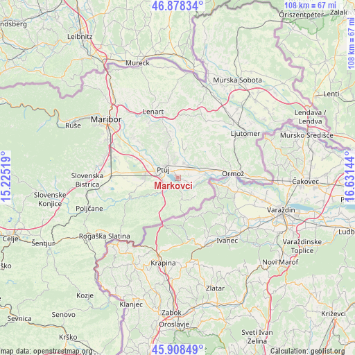
Markovci GPS coordinates[2]
46° 23' 44.052" North, 15° 55' 41.916" East
| Map corner | latitude | longitude |
|---|---|---|
| Upper-left | 46.87834°, | 15.22519° |
| Center: | 46.39557°, | 15.92831° |
| Lower-right: | 45.90849°, | 16.63144° |
| Map W x H: | 107.8×107.8 km | = 67×67mi |
| max Lat: | 46.83694° ⇑33.8% North |
| Markovci: | 46.39557° |
| min Lat: | ⇓66.2% South 45.47667° |
| min Long | Markovci | max Long |
| 13.52639° | 15.92831° | 16.4975° |
| W 87.3%⇐ | ⇒12.7% E |
Elevation
Elevation of Markovci is 222 m = 728 ft, and this is 103.6 m = 340 ft below average elevation for this country.
| Max E: |
1551 m = 5089 ft | 75.8% |
| Avg. | 325.6 m = 1068 ft | |
| Markovci | 222 m = 728 ft | |
Min E: |
2 m = 7 ft | 24.2% |
See also: Slovenia elevation on elevation.city.
Geographical zone
Markovci is located in North temperate zone (between Tropic of Cancer and the Arctic Circle). Distance of this North polar circle is 2242.5 km =1393.4 mi to North.| Distance of | km | miles | from Markovci |
|---|---|---|---|
| North Pole | 4848.4 | 3012.7 | to North |
| Arctic Circle | 2242.5 | 1393.4 | to North |
| Tropic Cancer | 2552.8 | 1586.2 | to South |
| Equator | 5158.7 | 3205.5 | to South |


Nearby cities:
15 places around Markovci: (largest is in red/bold)
• Bukovci
3 km =1.9 mi,  108°
108°
• Dornava
5 km =3.1 mi,  22°
22°
• Draženci
6.2 km =3.9 mi,  257°
257°
• Gorišnica
6.9 km =4.3 mi,  72°
72°
• Kicar
6.4 km =4 mi,  348°
348°
• Lancova Vas
6.2 km =3.9 mi,  243°
243°
• Moškanjci
5.7 km =3.5 mi,  61°
61°
• Pobrežje
4 km =2.5 mi,  252°
252°
• Podvinci
4.2 km =2.6 mi, 347°
• Ptuj
5.2 km =3.2 mi,  301°
301°
• Spodnja Hajdina
6.4 km =4 mi,  283°
283°
• Spuhlja
2.1 km =1.3 mi,  331°
331°
• Stojnci
4.5 km =2.8 mi, 111°
• Videm pri Ptuju
3.4 km =2.1 mi,  209°
209°
• Zgornja Hajdina
7 km =4.3 mi, 279°
Sources, notices
• [Note1] Compared only with cities in Slovenia existing in our database
• [Src1] Map data: © OpenStreetMap contributors (CC-BY-SA)
• [Src2] Other city data from geonames.org with taken over terms of usage.
• [Src3] Geographical zone / Annual Mean Temperature by Robert A. Rohde @ Wikipedia
