Voglje geodata
Voglje (Šenčur) is a populated place; located in Slovenia in Europe/Ljubljana (GMT+2) time zone. With population of 668 people, there are 381 cities with bigger population in this country. Compared to other cities in Slovenia, 57% of cities are located further ↑North; 67.8% of cities are located further →East and 70.3% of cities have lower elevation than Voglje. Note1


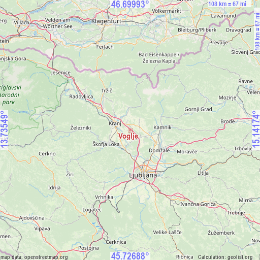
Voglje GPS coordinates[2]
46° 12' 56.016" North, 14° 26' 18.996" East
| Map corner | latitude | longitude |
|---|---|---|
| Upper-left | 46.69993°, | 13.73549° |
| Center: | 46.21556°, | 14.43861° |
| Lower-right: | 45.72688°, | 15.14174° |
| Map W x H: | 108.2×108.2 km | = 67.2×67.2mi |
| max Lat: | 46.83694° ⇑57% North |
| Voglje: | 46.21556° |
| min Lat: | ⇓43% South 45.47667° |
| min Long | Voglje | max Long |
| 13.52639° | 14.43861° | 16.4975° |
| W 32.2%⇐ | ⇒67.8% E |
Elevation
Elevation of Voglje is 373 m = 1224 ft, and this is 47.4 m = 156 ft above average elevation for this country.
| Max E: |
1551 m = 5089 ft | 29.7% |
| Voglje | 373 m 1224 ft | |
| Avg. | 325.6 m = 1068 ft | |
Min E: |
2 m = 7 ft | 70.3% |
See also: Slovenia elevation on elevation.city.
Geographical zone
Voglje is located in North temperate zone (between Tropic of Cancer and the Arctic Circle). Distance of this North polar circle is 2262.5 km =1405.9 mi to North.| Distance of | km | miles | from Voglje |
|---|---|---|---|
| North Pole | 4868.4 | 3025.1 | to North |
| Arctic Circle | 2262.5 | 1405.9 | to North |
| Tropic Cancer | 2532.8 | 1573.8 | to South |
| Equator | 5138.7 | 3193 | to South |


Nearby cities:
15 places around Voglje: (largest is in red/bold)
• Britof
6.2 km =3.9 mi,  323°
323°
• Cerklje na Gorenjskem
5.8 km =3.6 mi,  41°
41°
• Hotemaže
7.4 km =4.6 mi,  349°
349°
• Hrastje
3 km =1.9 mi,  272°
272°
• Kranj
6.9 km =4.3 mi,  292°
292°
• Podreča
5.1 km =3.2 mi,  202°
202°
• Predoslje
6.9 km =4.3 mi, 324°
• Trboje
2.4 km =1.5 mi,  224°
224°
• Valburga
5.5 km =3.4 mi,  184°
184°
• Visoko
6.4 km =4 mi, 345°
• Vodice
5.2 km =3.2 mi,  123°
123°
• Voklo
1.2 km =0.7 mi, 272°
• Zbilje
5.7 km =3.5 mi, 197°
• Zgornji Brnik
4.4 km =2.7 mi,  53°
53°
• Šenčur
3.6 km =2.2 mi,  336°
336°
Sources, notices
• [Note1] Compared only with cities in Slovenia existing in our database
• [Src1] Map data: © OpenStreetMap contributors (CC-BY-SA)
• [Src2] Other city data from geonames.org with taken over terms of usage.
• [Src3] Geographical zone / Annual Mean Temperature by Robert A. Rohde @ Wikipedia
