Tabor geodata
Tabor is a seat of a first-order administrative division; located in Slovenia in Europe/Ljubljana (GMT+2) time zone. With population of 406 people, there are 566 cities with bigger population in this country. Compared to other cities in Slovenia, 53.5% of cities are located further ↑North; 50% of cities are located further ←West and 58% of cities have lower elevation than Tabor. Note1


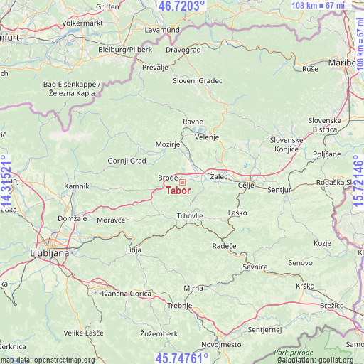
Tabor GPS coordinates[2]
46° 14' 9.996" North, 15° 1' 5.988" East
| Map corner | latitude | longitude |
|---|---|---|
| Upper-left | 46.7203°, | 14.31521° |
| Center: | 46.23611°, | 15.01833° |
| Lower-right: | 45.74761°, | 15.72146° |
| Map W x H: | 108.2×108.2 km | = 67.2×67.2mi |
| max Lat: | 46.83694° ⇑53.5% North |
| Tabor: | 46.23611° |
| min Lat: | ⇓46.5% South 45.47667° |
| min Long | Tabor | max Long |
| 13.52639° | 15.01833° | 16.4975° |
| W 50%⇐ | ⇒50% E |
Elevation
Elevation of Tabor is 320 m = 1050 ft, and this is 5.6 m = 18 ft below average elevation for this country.
| Max E: |
1551 m = 5089 ft | 42% |
| Avg. | 325.6 m = 1068 ft | |
| Tabor | 320 m = 1050 ft | |
Min E: |
2 m = 7 ft | 58% |
See also: Slovenia elevation on elevation.city.
Geographical zone
Tabor is located in North temperate zone (between Tropic of Cancer and the Arctic Circle). Distance of this North polar circle is 2260.2 km =1404.4 mi to North.| Distance of | km | miles | from Tabor |
|---|---|---|---|
| North Pole | 4866.1 | 3023.7 | to North |
| Arctic Circle | 2260.2 | 1404.4 | to North |
| Tropic Cancer | 2535.1 | 1575.2 | to South |
| Equator | 5141 | 3194.5 | to South |


Nearby cities:
15 places around Tabor: (largest is in red/bold)
• Braslovče
6.2 km =3.9 mi,  14°
14°
• Breg pri Polzeli
6.5 km =4 mi,  55°
55°
• Dolenja Vas
5.9 km =3.7 mi,  84°
84°
• Griže
10.2 km =6.3 mi,  94°
94°
• Latkova Vas
6.1 km =3.8 mi,  71°
71°
• Letuš
8.9 km =5.5 mi,  3°
3°
• Ločica ob Savinji
6.8 km =4.2 mi, 63°
• Parižlje
5.7 km =3.5 mi,  31°
31°
• Polzela
6.4 km =4 mi,  35°
35°
• Pongrac
9.1 km =5.7 mi,  103°
103°
• Prebold
5.7 km =3.5 mi, 89°
• Trbovlje
9.4 km =5.8 mi,  163°
163°
• Vransko
5.2 km =3.2 mi,  279°
279°
• Vrbje
10.2 km =6.3 mi, 81°
• Šempeter v Savinj. Dolini
8.3 km =5.2 mi, 74°
Sources, notices
• [Note1] Compared only with cities in Slovenia existing in our database
• [Src1] Map data: © OpenStreetMap contributors (CC-BY-SA)
• [Src2] Other city data from geonames.org with taken over terms of usage.
• [Src3] Geographical zone / Annual Mean Temperature by Robert A. Rohde @ Wikipedia
