Ljubljana geodata
Ljubljana is a capital of a political entity; located in Slovenia in Europe/Ljubljana (GMT+2) time zone. With population of 272,220 people, there are 0 cities with bigger population in this country. Compared to other cities in Slovenia, 70.3% of cities are located further ↑North; 65.8% of cities are located further →East and 50.7% of cities have higher elevation than Ljubljana. Note1


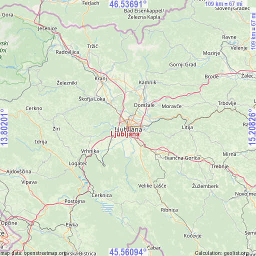
Ljubljana GPS coordinates[2]
46° 3' 3.888" North, 14° 30' 18.468" East
| Map corner | latitude | longitude |
|---|---|---|
| Upper-left | 46.53691°, | 13.80201° |
| Center: | 46.05108°, | 14.50513° |
| Lower-right: | 45.56094°, | 15.20826° |
| Map W x H: | 108.5×108.5 km | = 67.4×67.4mi |
| max Lat: | 46.83694° ⇑70.3% North |
| Ljubljana: | 46.05108° |
| min Lat: | ⇓29.7% South 45.47667° |
| min Long | Ljubljana | max Long |
| 13.52639° | 14.50513° | 16.4975° |
| W 34.2%⇐ | ⇒65.8% E |
Elevation
Elevation of Ljubljana is 295 m = 968 ft, and this is 30.6 m = 100 ft below average elevation for this country.
| Max E: |
1551 m = 5089 ft | 50.7% |
| Avg. | 325.6 m = 1068 ft | |
| Ljubljana | 295 m = 968 ft | |
Min E: |
2 m = 7 ft | 49.3% |
See also: Ljubljana elevation on elevation.city.
Geographical zone
Ljubljana is located in North temperate zone (between Tropic of Cancer and the Arctic Circle). Distance of this North polar circle is 2280.8 km =1417.2 mi to North.| Distance of | km | miles | from Ljubljana |
|---|---|---|---|
| North Pole | 4886.7 | 3036.5 | to North |
| Arctic Circle | 2280.8 | 1417.2 | to North |
| Tropic Cancer | 2514.5 | 1562.4 | to South |
| Equator | 5120.4 | 3181.7 | to South |


Nearby cities:
15 places around Ljubljana: (largest is in red/bold)
• Brezovica pri Ljubljani
8.4 km =5.2 mi,  256°
256°
• Dobrova
8.8 km =5.5 mi,  266°
266°
• Dol pri Ljubljani
8.5 km =5.3 mi,  60°
60°
• Dragomelj
9.1 km =5.7 mi,  43°
43°
• Dragomer
10.2 km =6.3 mi,  247°
247°
• Ig
10.3 km =6.4 mi,  169°
169°
• Lavrica
7 km =4.3 mi,  144°
144°
• Lukovica pri Brezovici
9.5 km =5.9 mi, 245°
• Spodnje Gameljne
7.3 km =4.5 mi,  356°
356°
• Srednje Gameljne
8.7 km =5.4 mi, 359°
• Stanežiče
9.2 km =5.7 mi,  322°
322°
• Trzin
10.3 km =6.4 mi,  27°
27°
• Vnanje Gorice
8.1 km =5 mi,  232°
232°
• Črna Vas
6.6 km =4.1 mi,  203°
203°
• Škofljica
9.3 km =5.8 mi, 143°
Sources, notices
• [Note1] Compared only with cities in Slovenia existing in our database
• [Src1] Map data: © OpenStreetMap contributors (CC-BY-SA)
• [Src2] Other city data from geonames.org with taken over terms of usage.
• [Src3] Geographical zone / Annual Mean Temperature by Robert A. Rohde @ Wikipedia
