Kovor geodata
Kovor (Tržič) is a populated place; located in Slovenia in Europe/Ljubljana (GMT+2) time zone. With population of 788 people, there are 305 cities with bigger population in this country. Compared to other cities in Slovenia, 60.2% of cities are located further ↓South; 79% of cities are located further →East and 90.8% of cities have lower elevation than Kovor. Note1


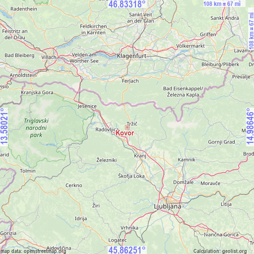
Kovor GPS coordinates[2]
46° 21' 0" North, 14° 16' 59.988" East
| Map corner | latitude | longitude |
|---|---|---|
| Upper-left | 46.83318°, | 13.58021° |
| Center: | 46.35°, | 14.28333° |
| Lower-right: | 45.86251°, | 14.98646° |
| Map W x H: | 107.9×107.9 km | = 67×67mi |
| max Lat: | 46.83694° ⇑39.8% North |
| Kovor: | 46.35° |
| min Lat: | ⇓60.2% South 45.47667° |
| min Long | Kovor | max Long |
| 13.52639° | 14.28333° | 16.4975° |
| W 21%⇐ | ⇒79% E |
Elevation
Elevation of Kovor is 541 m = 1775 ft, and this is 215.4 m = 707 ft above average elevation for this country.
| Max E: |
1551 m = 5089 ft | 9.2% |
| Kovor | 541 m 1775 ft | |
| Avg. | 325.6 m = 1068 ft | |
Min E: |
2 m = 7 ft | 90.8% |
See also: Slovenia elevation on elevation.city.
Geographical zone
Kovor is located in North temperate zone (between Tropic of Cancer and the Arctic Circle). Distance of this North polar circle is 2247.5 km =1396.5 mi to North.| Distance of | km | miles | from Kovor |
|---|---|---|---|
| North Pole | 4853.4 | 3015.8 | to North |
| Arctic Circle | 2247.5 | 1396.5 | to North |
| Tropic Cancer | 2547.7 | 1583.1 | to South |
| Equator | 5153.6 | 3202.3 | to South |


Nearby cities:
15 places around Kovor: (largest is in red/bold)
• Begunje na Gorenjskem
6.3 km =3.9 mi,  305°
305°
• Bistrica pri Tržiču
0.8 km =0.5 mi,  50°
50°
• Brezje
4.6 km =2.9 mi,  239°
239°
• Golnik
4.3 km =2.7 mi,  115°
115°
• Kamna Gorica
7.4 km =4.6 mi, 239°
• Križe
1.6 km =1 mi, 120°
• Podbrezje
5.6 km =3.5 mi,  180°
180°
• Podljubelj
6.9 km =4.3 mi,  354°
354°
• Pristava
1.3 km =0.8 mi,  94°
94°
• Radovljica
8.4 km =5.2 mi,  265°
265°
• Ročevnica
0.4 km =0.2 mi,  19°
19°
• Spodnje Duplje
5.7 km =3.5 mi,  167°
167°
• Strahinj
7.8 km =4.8 mi,  160°
160°
• Tržič
2.6 km =1.6 mi, 54°
• Zgornje Duplje
4.8 km =3 mi, 172°
Sources, notices
• [Note1] Compared only with cities in Slovenia existing in our database
• [Src1] Map data: © OpenStreetMap contributors (CC-BY-SA)
• [Src2] Other city data from geonames.org with taken over terms of usage.
• [Src3] Geographical zone / Annual Mean Temperature by Robert A. Rohde @ Wikipedia
