Kropa geodata
Kropa (Radovljica) is a populated place; located in Slovenia in Europe/Ljubljana (GMT+2) time zone. With population of 807 people, there are 292 cities with bigger population in this country. Compared to other cities in Slovenia, 54.5% of cities are located further ↓South; 81.2% of cities are located further →East and 94.2% of cities have lower elevation than Kropa. Note1


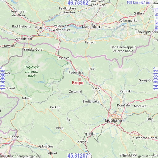
Kropa GPS coordinates[2]
46° 18' 0" North, 14° 12' 0" East
| Map corner | latitude | longitude |
|---|---|---|
| Upper-left | 46.78362°, | 13.49688° |
| Center: | 46.3°, | 14.2° |
| Lower-right: | 45.81207°, | 14.90313° |
| Map W x H: | 108×108 km | = 67.1×67.1mi |
| max Lat: | 46.83694° ⇑45.5% North |
| Kropa: | 46.3° |
| min Lat: | ⇓54.5% South 45.47667° |
| min Long | Kropa | max Long |
| 13.52639° | 14.2° | 16.4975° |
| W 18.8%⇐ | ⇒81.2% E |
Elevation
Elevation of Kropa is 588 m = 1929 ft, and this is 262.4 m = 861 ft above average elevation for this country.
| Max E: |
1551 m = 5089 ft | 5.8% |
| Kropa | 588 m 1929 ft | |
| Avg. | 325.6 m = 1068 ft | |
Min E: |
2 m = 7 ft | 94.2% |
See also: Slovenia elevation on elevation.city.
Geographical zone
Kropa is located in North temperate zone (between Tropic of Cancer and the Arctic Circle). Distance of this North polar circle is 2253.1 km =1400 mi to North.| Distance of | km | miles | from Kropa |
|---|---|---|---|
| North Pole | 4859 | 3019.2 | to North |
| Arctic Circle | 2253.1 | 1400 | to North |
| Tropic Cancer | 2542.2 | 1579.6 | to South |
| Equator | 5148.1 | 3198.9 | to South |


Nearby cities:
15 places around Kropa: (largest is in red/bold)
• Brezje
4.1 km =2.5 mi,  37°
37°
• Kamna Gorica
1.9 km =1.2 mi,  0°
0°
• Kovor
8.5 km =5.3 mi,  49°
49°
• Križe
9.1 km =5.7 mi,  58°
58°
• Lesce
7.5 km =4.7 mi,  334°
334°
• Podbrezje
6.4 km =4 mi,  90°
90°
• Radovljica
5.3 km =3.3 mi,  338°
338°
• Ribno
7.6 km =4.7 mi,  293°
293°
• Ročevnica
8.8 km =5.5 mi, 47°
• Selca
8.4 km =5.2 mi,  177°
177°
• Spodnje Duplje
7.7 km =4.8 mi, 90°
• Strahinj
9.2 km =5.7 mi,  101°
101°
• Zgornja Besnica
7.4 km =4.6 mi,  120°
120°
• Zgornje Duplje
7.1 km =4.4 mi,  83°
83°
• Železniki
8.6 km =5.3 mi,  194°
194°
Sources, notices
• [Note1] Compared only with cities in Slovenia existing in our database
• [Src1] Map data: © OpenStreetMap contributors (CC-BY-SA)
• [Src2] Other city data from geonames.org with taken over terms of usage.
• [Src3] Geographical zone / Annual Mean Temperature by Robert A. Rohde @ Wikipedia
