Kozina geodata
Kozina (Hrpelje-Kozina) is a seat of a first-order administrative division; located in Slovenia in Europe/Ljubljana (GMT+2) time zone. With population of 544 people, there are 490 cities with bigger population in this country. Compared to other cities in Slovenia, 93.3% of cities are located further ↑North; 88.2% of cities are located further →East and 87% of cities have lower elevation than Kozina. Note1


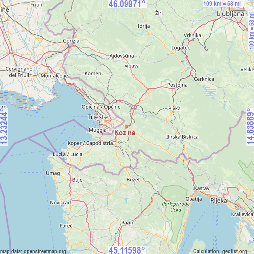
Kozina GPS coordinates[2]
45° 36' 36" North, 13° 56' 8.016" East
| Map corner | latitude | longitude |
|---|---|---|
| Upper-left | 46.09971°, | 13.23244° |
| Center: | 45.61°, | 13.93556° |
| Lower-right: | 45.11598°, | 14.63869° |
| Map W x H: | 109.4×109.4 km | = 68×68mi |
| max Lat: | 46.83694° ⇑93.3% North |
| Kozina: | 45.61° |
| min Lat: | ⇓6.7% South 45.47667° |
| min Long | Kozina | max Long |
| 13.52639° | 13.93556° | 16.4975° |
| W 11.8%⇐ | ⇒88.2% E |
Elevation
Elevation of Kozina is 494 m = 1621 ft, and this is 168.4 m = 552 ft above average elevation for this country.
| Max E: |
1551 m = 5089 ft | 13% |
| Kozina | 494 m 1621 ft | |
| Avg. | 325.6 m = 1068 ft | |
Min E: |
2 m = 7 ft | 87% |
See also: Slovenia elevation on elevation.city.
Geographical zone
Kozina is located in North temperate zone (between Tropic of Cancer and the Arctic Circle). Distance of this North polar circle is 2329.8 km =1447.7 mi to North.| Distance of | km | miles | from Kozina |
|---|---|---|---|
| North Pole | 4935.7 | 3066.9 | to North |
| Arctic Circle | 2329.8 | 1447.7 | to North |
| Tropic Cancer | 2465.4 | 1531.9 | to South |
| Equator | 5071.4 | 3151.2 | to South |


Nearby cities:
15 places around Kozina: (largest is in red/bold)
• Bertoki
14.9 km =9.3 mi,  241°
241°
• Dekani
11.6 km =7.2 mi,  234°
234°
• Divača
8.7 km =5.4 mi,  17°
17°
• Hrpelje
0.6 km =0.4 mi,  118°
118°
• Hrvatini
14.2 km =8.8 mi,  257°
257°
• Kolomban
14.8 km =9.2 mi, 261°
• Lokev
5.7 km =3.5 mi,  354°
354°
• Pobegi
13.4 km =8.3 mi, 234°
• Prade
14.6 km =9.1 mi, 237°
• Senožeče
14.8 km =9.2 mi,  33°
33°
• Sežana
12 km =7.5 mi,  336°
336°
• Spodnje Škofije
11.9 km =7.4 mi,  249°
249°
• Sv. Anton
12.4 km =7.7 mi,  220°
220°
• Zgornje Škofije
11.6 km =7.2 mi, 245°
• Čežarji
12.8 km =8 mi, 232°
Sources, notices
• [Note1] Compared only with cities in Slovenia existing in our database
• [Src1] Map data: © OpenStreetMap contributors (CC-BY-SA)
• [Src2] Other city data from geonames.org with taken over terms of usage.
• [Src3] Geographical zone / Annual Mean Temperature by Robert A. Rohde @ Wikipedia
