Senožeče geodata
Senožeče (Divača) is a populated place; located in Slovenia in Europe/Ljubljana (GMT+2) time zone. With population of 610 people, there are 435 cities with bigger population in this country. Compared to other cities in Slovenia, 90.5% of cities are located further ↑North; 85.8% of cities are located further →East and 93.5% of cities have lower elevation than Senožeče. Note1


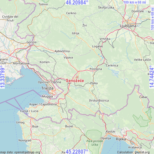
Senožeče GPS coordinates[2]
45° 43' 15.996" North, 14° 2' 27.996" East
| Map corner | latitude | longitude |
|---|---|---|
| Upper-left | 46.20984°, | 13.33799° |
| Center: | 45.72111°, | 14.04111° |
| Lower-right: | 45.22807°, | 14.74424° |
| Map W x H: | 109.2×109.2 km | = 67.9×67.9mi |
| max Lat: | 46.83694° ⇑90.5% North |
| Senožeče: | 45.72111° |
| min Lat: | ⇓9.5% South 45.47667° |
| min Long | Senožeče | max Long |
| 13.52639° | 14.04111° | 16.4975° |
| W 14.2%⇐ | ⇒85.8% E |
Elevation
Elevation of Senožeče is 575 m = 1886 ft, and this is 249.4 m = 818 ft above average elevation for this country.
| Max E: |
1551 m = 5089 ft | 6.5% |
| Senožeče | 575 m 1886 ft | |
| Avg. | 325.6 m = 1068 ft | |
Min E: |
2 m = 7 ft | 93.5% |
See also: Slovenia elevation on elevation.city.
Geographical zone
Senožeče is located in North temperate zone (between Tropic of Cancer and the Arctic Circle). Distance of this North polar circle is 2317.5 km =1440 mi to North.| Distance of | km | miles | from Senožeče |
|---|---|---|---|
| North Pole | 4923.4 | 3059.3 | to North |
| Arctic Circle | 2317.5 | 1440 | to North |
| Tropic Cancer | 2477.8 | 1539.6 | to South |
| Equator | 5083.7 | 3158.9 | to South |


Nearby cities:
15 places around Senožeče: (largest is in red/bold)
• Ajdovščina
21 km =13 mi,  330°
330°
• Budanje
18.5 km =11.5 mi,  337°
337°
• Divača
6.8 km =4.2 mi,  233°
233°
• Dutovlje
16.7 km =10.4 mi,  284°
284°
• Hrpelje
14.8 km =9.2 mi,  211°
211°
• Kozina
14.8 km =9.2 mi, 213°
• Križ
13.9 km =8.6 mi, 280°
• Lokev
11 km =6.8 mi, 232°
• Pivka
12.7 km =7.9 mi,  109°
109°
• Planina
20.1 km =12.5 mi,  53°
53°
• Postojna
14.8 km =9.2 mi,  66°
66°
• Prestranek
11.3 km =7 mi,  84°
84°
• Sežana
13.1 km =8.1 mi,  264°
264°
• Vipava
15.2 km =9.4 mi, 336°
• Vrhpolje
17.1 km =10.6 mi, 338°
Sources, notices
• [Note1] Compared only with cities in Slovenia existing in our database
• [Src1] Map data: © OpenStreetMap contributors (CC-BY-SA)
• [Src2] Other city data from geonames.org with taken over terms of usage.
• [Src3] Geographical zone / Annual Mean Temperature by Robert A. Rohde @ Wikipedia
