Komen geodata
Komen is a seat of a first-order administrative division; located in Slovenia in Europe/Ljubljana (GMT+2) time zone. With population of 650 people, there are 394 cities with bigger population in this country. Compared to other cities in Slovenia, 87.8% of cities are located further ↑North; 92.7% of cities are located further →East and 62% of cities have higher elevation than Komen. Note1


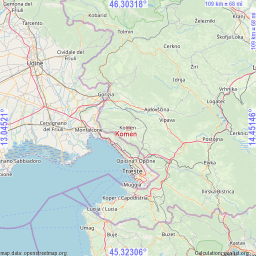
Komen GPS coordinates[2]
45° 48' 55.008" North, 13° 44' 53.988" East
| Map corner | latitude | longitude |
|---|---|---|
| Upper-left | 46.30318°, | 13.04521° |
| Center: | 45.81528°, | 13.74833° |
| Lower-right: | 45.32306°, | 14.45146° |
| Map W x H: | 109×109 km | = 67.7×67.7mi |
| max Lat: | 46.83694° ⇑87.8% North |
| Komen: | 45.81528° |
| min Lat: | ⇓12.2% South 45.47667° |
| min Long | Komen | max Long |
| 13.52639° | 13.74833° | 16.4975° |
| W 7.3%⇐ | ⇒92.7% E |
Elevation
Elevation of Komen is 267 m = 876 ft, and this is 58.6 m = 192 ft below average elevation for this country.
| Max E: |
1551 m = 5089 ft | 62% |
| Avg. | 325.6 m = 1068 ft | |
| Komen | 267 m = 876 ft | |
Min E: |
2 m = 7 ft | 38% |
See also: Slovenia elevation on elevation.city.
Geographical zone
Komen is located in North temperate zone (between Tropic of Cancer and the Arctic Circle). Distance of this North polar circle is 2307 km =1433.5 mi to North.| Distance of | km | miles | from Komen |
|---|---|---|---|
| North Pole | 4912.9 | 3052.7 | to North |
| Arctic Circle | 2307 | 1433.5 | to North |
| Tropic Cancer | 2488.3 | 1546.2 | to South |
| Equator | 5094.2 | 3165.4 | to South |


Nearby cities:
15 places around Komen: (largest is in red/bold)
• Bilje
12.6 km =7.8 mi,  314°
314°
• Branik
5.4 km =3.4 mi,  30°
30°
• Cesta
12.4 km =7.7 mi,  49°
49°
• Dornberk
8.3 km =5.2 mi,  353°
353°
• Dutovlje
9.1 km =5.7 mi,  134°
134°
• Gradišče nad Prvačino
8.9 km =5.5 mi,  336°
336°
• Križ
12 km =7.5 mi, 130°
• Lokavec
14 km =8.7 mi, 46°
• Prvačina
8.6 km =5.3 mi, 344°
• Renče
10.4 km =6.5 mi,  323°
323°
• Vitovlje
13.8 km =8.6 mi,  5°
5°
• Vogrsko
10.8 km =6.7 mi, 339°
• Volčja Draga
11.6 km =7.2 mi,  331°
331°
• Vrtojba
14 km =8.7 mi, 320°
• Šempas
12.8 km =8 mi,  358°
358°
Sources, notices
• [Note1] Compared only with cities in Slovenia existing in our database
• [Src1] Map data: © OpenStreetMap contributors (CC-BY-SA)
• [Src2] Other city data from geonames.org with taken over terms of usage.
• [Src3] Geographical zone / Annual Mean Temperature by Robert A. Rohde @ Wikipedia
