Cesta geodata
Cesta (Ajdovščina) is a populated place; located in Slovenia in Europe/Ljubljana (GMT+2) time zone. With population of 538 people, there are 500 cities with bigger population in this country. Compared to other cities in Slovenia, 84.8% of cities are located further ↑North; 89.3% of cities are located further →East and 92.8% of cities have higher elevation than Cesta. Note1


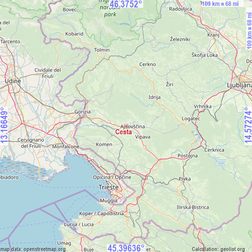
Cesta GPS coordinates[2]
45° 53' 16.584" North, 13° 52' 10.596" East
| Map corner | latitude | longitude |
|---|---|---|
| Upper-left | 46.3752°, | 13.16649° |
| Center: | 45.88794°, | 13.86961° |
| Lower-right: | 45.39636°, | 14.57274° |
| Map W x H: | 108.8×108.8 km | = 67.6×67.6mi |
| max Lat: | 46.83694° ⇑84.8% North |
| Cesta: | 45.88794° |
| min Lat: | ⇓15.2% South 45.47667° |
| min Long | Cesta | max Long |
| 13.52639° | 13.86961° | 16.4975° |
| W 10.7%⇐ | ⇒89.3% E |
Elevation
Elevation of Cesta is 114 m = 374 ft, and this is 211.6 m = 694 ft below average elevation for this country.
| Max E: |
1551 m = 5089 ft | 92.8% |
| Avg. | 325.6 m = 1068 ft | |
| Cesta | 114 m = 374 ft | |
Min E: |
2 m = 7 ft | 7.2% |
See also: Slovenia elevation on elevation.city.
Geographical zone
Cesta is located in North temperate zone (between Tropic of Cancer and the Arctic Circle). Distance of this North polar circle is 2298.9 km =1428.5 mi to North.| Distance of | km | miles | from Cesta |
|---|---|---|---|
| North Pole | 4904.8 | 3047.7 | to North |
| Arctic Circle | 2298.9 | 1428.5 | to North |
| Tropic Cancer | 2496.3 | 1551.1 | to South |
| Equator | 5102.3 | 3170.4 | to South |


Nearby cities:
15 places around Cesta: (largest is in red/bold)
• Ajdovščina
3.1 km =1.9 mi,  93°
93°
• Branik
7.4 km =4.6 mi,  242°
242°
• Budanje
6.2 km =3.9 mi,  103°
103°
• Dornberk
10.3 km =6.4 mi,  271°
271°
• Gradišče nad Prvačino
13 km =8.1 mi, 270°
• Komen
12.4 km =7.7 mi,  229°
229°
• Lokavec
1.7 km =1.1 mi,  27°
27°
• Ozeljan
12.4 km =7.7 mi,  299°
299°
• Prvačina
11.7 km =7.3 mi, 271°
• Vipava
8.6 km =5.3 mi,  122°
122°
• Vitovlje
9.9 km =6.2 mi,  305°
305°
• Vogrsko
13.2 km =8.2 mi,  278°
278°
• Vrhpolje
7.6 km =4.7 mi,  110°
110°
• Črni Vrh
14.1 km =8.8 mi,  73°
73°
• Šempas
10.8 km =6.7 mi, 295°
Sources, notices
• [Note1] Compared only with cities in Slovenia existing in our database
• [Src1] Map data: © OpenStreetMap contributors (CC-BY-SA)
• [Src2] Other city data from geonames.org with taken over terms of usage.
• [Src3] Geographical zone / Annual Mean Temperature by Robert A. Rohde @ Wikipedia
