Rakitna geodata
Rakitna (Brezovica) is a populated place; located in Slovenia in Europe/Ljubljana (GMT+2) time zone. With population of 672 people, there are 376 cities with bigger population in this country. Compared to other cities in Slovenia, 84.7% of cities are located further ↑North; 67.5% of cities are located further →East and 97.7% of cities have lower elevation than Rakitna. Note1


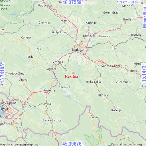
Rakitna GPS coordinates[2]
45° 53' 17.988" North, 14° 26' 39.012" East
| Map corner | latitude | longitude |
|---|---|---|
| Upper-left | 46.37559°, | 13.74105° |
| Center: | 45.88833°, | 14.44417° |
| Lower-right: | 45.39676°, | 15.1473° |
| Map W x H: | 108.8×108.8 km | = 67.6×67.6mi |
| max Lat: | 46.83694° ⇑84.7% North |
| Rakitna: | 45.88833° |
| min Lat: | ⇓15.3% South 45.47667° |
| min Long | Rakitna | max Long |
| 13.52639° | 14.44417° | 16.4975° |
| W 32.5%⇐ | ⇒67.5% E |
Elevation
Elevation of Rakitna is 791 m = 2595 ft, and this is 465.4 m = 1527 ft above average elevation for this country.
| Max E: |
1551 m = 5089 ft | 2.3% |
| Rakitna | 791 m 2595 ft | |
| Avg. | 325.6 m = 1068 ft | |
Min E: |
2 m = 7 ft | 97.7% |
See also: Slovenia elevation on elevation.city.
Geographical zone
Rakitna is located in North temperate zone (between Tropic of Cancer and the Arctic Circle). Distance of this North polar circle is 2298.9 km =1428.5 mi to North.| Distance of | km | miles | from Rakitna |
|---|---|---|---|
| North Pole | 4904.8 | 3047.7 | to North |
| Arctic Circle | 2298.9 | 1428.5 | to North |
| Tropic Cancer | 2496.4 | 1551.2 | to South |
| Equator | 5102.3 | 3170.4 | to South |


Nearby cities:
15 places around Rakitna: (largest is in red/bold)
• Begunje pri Cerknici
9.2 km =5.7 mi,  211°
211°
• Bevke
12.6 km =7.8 mi,  327°
327°
• Borovnica
7 km =4.3 mi,  295°
295°
• Cerknica
12.3 km =7.6 mi, 210°
• Gradišče
11.7 km =7.3 mi,  71°
71°
• Ig
10.3 km =6.4 mi,  39°
39°
• Jezero
9.1 km =5.7 mi,  354°
354°
• Kamnik pod Krimom
7.1 km =4.4 mi,  335°
335°
• Notranje Gorice
11.6 km =7.2 mi, 342°
• Pijava Gorica
12.1 km =7.5 mi,  54°
54°
• Podpeč
9.3 km =5.8 mi, 347°
• Rakek
13.3 km =8.3 mi,  231°
231°
• Smrjene
12.7 km =7.9 mi,  64°
64°
• Verd
13.1 km =8.1 mi,  305°
305°
• Črna Vas
12.2 km =7.6 mi,  9°
9°
Sources, notices
• [Note1] Compared only with cities in Slovenia existing in our database
• [Src1] Map data: © OpenStreetMap contributors (CC-BY-SA)
• [Src2] Other city data from geonames.org with taken over terms of usage.
• [Src3] Geographical zone / Annual Mean Temperature by Robert A. Rohde @ Wikipedia
