Hrib-Loški Potok geodata
Hrib-Loški Potok (Loški Potok) is a seat of a first-order administrative division; located in Slovenia in Europe/Ljubljana (GMT+2) time zone. With population of 373 people, there are 573 cities with bigger population in this country. Compared to other cities in Slovenia, 91.2% of cities are located further ↑North; 59.8% of cities are located further →East and 97.8% of cities have lower elevation than Hrib-Loški Potok. Note1


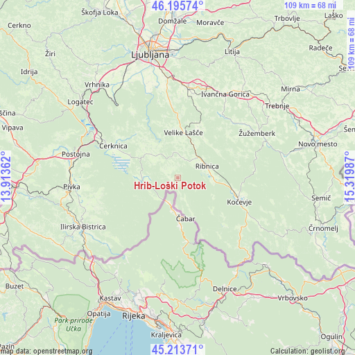
Hrib-Loški Potok GPS coordinates[2]
45° 42' 24.768" North, 14° 37' 0.264" East
| Map corner | latitude | longitude |
|---|---|---|
| Upper-left | 46.19574°, | 13.91362° |
| Center: | 45.70688°, | 14.61674° |
| Lower-right: | 45.21371°, | 15.31987° |
| Map W x H: | 109.2×109.2 km | = 67.9×67.9mi |
| max Lat: | 46.83694° ⇑91.2% North |
| Hrib-Loški Potok: | 45.70688° |
| min Lat: | ⇓8.8% South 45.47667° |
| min Long | Hrib-Loški Pot | max Long |
| 13.52639° | 14.61674° | 16.4975° |
| W 40.2%⇐ | ⇒59.8% E |
Elevation
Elevation of Hrib-Loški Potok is 797 m = 2615 ft, and this is 471.4 m = 1547 ft above average elevation for this country.
| Max E: |
1551 m = 5089 ft | 2.2% |
| Hrib-Loški Potok | 797 m 2615 ft | |
| Avg. | 325.6 m = 1068 ft | |
Min E: |
2 m = 7 ft | 97.8% |
See also: Slovenia elevation on elevation.city.
Geographical zone
Hrib-Loški Potok is located in North temperate zone (between Tropic of Cancer and the Arctic Circle). Distance of this North polar circle is 2319 km =1441 mi to North.| Distance of | km | miles | from Hrib-Loški Potok |
|---|---|---|---|
| North Pole | 4924.9 | 3060.2 | to North |
| Arctic Circle | 2319 | 1441 | to North |
| Tropic Cancer | 2476.2 | 1538.6 | to South |
| Equator | 5082.1 | 3157.9 | to South |


Nearby cities:
15 places around Hrib-Loški Potok: (largest is in red/bold)
• Cerknica
21.9 km =13.6 mi,  295°
295°
• Dolenja Vas
10.7 km =6.6 mi,  90°
90°
• Kočevje
20.4 km =12.7 mi,  110°
110°
• Leskova Dolina
15.4 km =9.6 mi,  231°
231°
• Loški Potok
2.9 km =1.8 mi,  257°
257°
• Lož
11.6 km =7.2 mi,  279°
279°
• Nova Vas
11.2 km =7 mi,  309°
309°
• Osilnica
20.8 km =12.9 mi,  162°
162°
• Ribnica
9.3 km =5.8 mi,  67°
67°
• Sodražica
6.2 km =3.9 mi,  13°
13°
• Stari Trg pri Ložu
11.4 km =7.1 mi,  274°
274°
• Velike Lašče
14 km =8.7 mi, 6°
• Videm
17 km =10.6 mi,  20°
20°
• Šalka Vas
21.5 km =13.4 mi, 106°
• Željne
21.6 km =13.4 mi,  104°
104°
Sources, notices
• [Note1] Compared only with cities in Slovenia existing in our database
• [Src1] Map data: © OpenStreetMap contributors (CC-BY-SA)
• [Src2] Other city data from geonames.org with taken over terms of usage.
• [Src3] Geographical zone / Annual Mean Temperature by Robert A. Rohde @ Wikipedia
