Ribnica geodata
Ribnica is a seat of a first-order administrative division; located in Slovenia in Europe/Ljubljana (GMT+2) time zone. With population of 3,604 people, there are 52 cities with bigger population in this country. Compared to other cities in Slovenia, 90% of cities are located further ↑North; 56.5% of cities are located further →East and 87.2% of cities have lower elevation than Ribnica. Note1


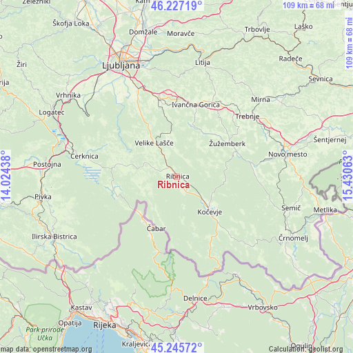
Ribnica GPS coordinates[2]
45° 44' 18.996" North, 14° 43' 39" East
| Map corner | latitude | longitude |
|---|---|---|
| Upper-left | 46.22719°, | 14.02438° |
| Center: | 45.73861°, | 14.7275° |
| Lower-right: | 45.24572°, | 15.43063° |
| Map W x H: | 109.1×109.1 km | = 67.8×67.8mi |
| max Lat: | 46.83694° ⇑90% North |
| Ribnica: | 45.73861° |
| min Lat: | ⇓10% South 45.47667° |
| min Long | Ribnica | max Long |
| 13.52639° | 14.7275° | 16.4975° |
| W 43.5%⇐ | ⇒56.5% E |
Elevation
Elevation of Ribnica is 495 m = 1624 ft, and this is 169.4 m = 556 ft above average elevation for this country.
| Max E: |
1551 m = 5089 ft | 12.8% |
| Ribnica | 495 m 1624 ft | |
| Avg. | 325.6 m = 1068 ft | |
Min E: |
2 m = 7 ft | 87.2% |
See also: Slovenia elevation on elevation.city.
Geographical zone
Ribnica is located in North temperate zone (between Tropic of Cancer and the Arctic Circle). Distance of this North polar circle is 2315.5 km =1438.8 mi to North.| Distance of | km | miles | from Ribnica |
|---|---|---|---|
| North Pole | 4921.4 | 3058 | to North |
| Arctic Circle | 2315.5 | 1438.8 | to North |
| Tropic Cancer | 2479.7 | 1540.8 | to South |
| Equator | 5085.7 | 3160.1 | to South |


Nearby cities:
15 places around Ribnica: (largest is in red/bold)
• Dolenja Vas
4.2 km =2.6 mi,  149°
149°
• Dolga Vas
18.2 km =11.3 mi,  137°
137°
• Hrib-Loški Potok
9.3 km =5.8 mi,  247°
247°
• Kočevje
15 km =9.3 mi, 135°
• Loški Potok
12.2 km =7.6 mi, 250°
• Lož
20.1 km =12.5 mi,  265°
265°
• Nova Vas
17.6 km =10.9 mi,  282°
282°
• Sodražica
7.6 km =4.7 mi,  289°
289°
• Spodnja Slivnica
21.4 km =13.3 mi,  345°
345°
• Stari Trg pri Ložu
20.1 km =12.5 mi,  262°
262°
• Velike Lašče
12.6 km =7.8 mi,  325°
325°
• Videm
12.7 km =7.9 mi, 348°
• Šalka Vas
15.3 km =9.5 mi,  128°
128°
• Željne
15.2 km =9.4 mi, 125°
• Žužemberk
18.9 km =11.7 mi,  55°
55°
Sources, notices
• [Note1] Compared only with cities in Slovenia existing in our database
• [Src1] Map data: © OpenStreetMap contributors (CC-BY-SA)
• [Src2] Other city data from geonames.org with taken over terms of usage.
• [Src3] Geographical zone / Annual Mean Temperature by Robert A. Rohde @ Wikipedia
