Željne geodata
Željne (Kočevje) is a populated place; located in Slovenia in Europe/Ljubljana (GMT+2) time zone. With population of 555 people, there are 478 cities with bigger population in this country. Compared to other cities in Slovenia, 92.2% of cities are located further ↑North; 53% of cities are located further →East and 85.3% of cities have lower elevation than Željne. Note1


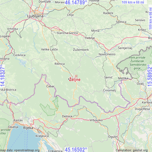
Željne GPS coordinates[2]
45° 39' 30.996" North, 14° 53' 11.004" East
| Map corner | latitude | longitude |
|---|---|---|
| Upper-left | 46.14789°, | 14.18327° |
| Center: | 45.65861°, | 14.88639° |
| Lower-right: | 45.16502°, | 15.58952° |
| Map W x H: | 109.3×109.3 km | = 67.9×67.9mi |
| max Lat: | 46.83694° ⇑92.2% North |
| Željne: | 45.65861° |
| min Lat: | ⇓7.8% South 45.47667° |
| min Long | Željne | max Long |
| 13.52639° | 14.88639° | 16.4975° |
| W 47%⇐ | ⇒53% E |
Elevation
Elevation of Željne is 473 m = 1552 ft, and this is 147.4 m = 484 ft above average elevation for this country.
| Max E: |
1551 m = 5089 ft | 14.7% |
| Željne | 473 m 1552 ft | |
| Avg. | 325.6 m = 1068 ft | |
Min E: |
2 m = 7 ft | 85.3% |
See also: Slovenia elevation on elevation.city.
Geographical zone
Željne is located in North temperate zone (between Tropic of Cancer and the Arctic Circle). Distance of this North polar circle is 2324.4 km =1444.3 mi to North.| Distance of | km | miles | from Željne |
|---|---|---|---|
| North Pole | 4930.3 | 3063.5 | to North |
| Arctic Circle | 2324.4 | 1444.3 | to North |
| Tropic Cancer | 2470.8 | 1535.3 | to South |
| Equator | 5076.8 | 3154.6 | to South |


Nearby cities:
15 places around Željne: (largest is in red/bold)
• Dolenja Vas
11.5 km =7.1 mi,  297°
297°
• Dolenjske Toplice
17.3 km =10.7 mi,  50°
50°
• Dolga Vas
4.6 km =2.9 mi,  181°
181°
• Hrib-Loški Potok
21.6 km =13.4 mi,  284°
284°
• Kostel
16.8 km =10.4 mi,  173°
173°
• Kočevje
2.5 km =1.6 mi,  226°
226°
• Lokve
23.2 km =14.4 mi,  105°
105°
• Osilnica
20.5 km =12.7 mi, 225°
• Ribnica
15.2 km =9.4 mi,  305°
305°
• Semič
23 km =14.3 mi,  93°
93°
• Sodražica
22.6 km =14 mi, 300°
• Straža
19.8 km =12.3 mi, 46°
• Uršna Sela
19.7 km =12.2 mi,  70°
70°
• Šalka Vas
0.7 km =0.4 mi,  207°
207°
• Žužemberk
19.8 km =12.3 mi,  9°
9°
Sources, notices
• [Note1] Compared only with cities in Slovenia existing in our database
• [Src1] Map data: © OpenStreetMap contributors (CC-BY-SA)
• [Src2] Other city data from geonames.org with taken over terms of usage.
• [Src3] Geographical zone / Annual Mean Temperature by Robert A. Rohde @ Wikipedia
