Čentiba geodata
Čentiba (Lendava-Lendva) is a populated place; located in Slovenia in Europe/Ljubljana (GMT+2) time zone. With population of 839 people, there are 274 cities with bigger population in this country. Compared to other cities in Slovenia, 86% of cities are located further ↓South; 100% of cities are located further ←West and 80% of cities have higher elevation than Čentiba. Note1


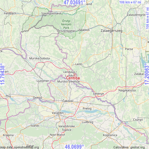
Čentiba GPS coordinates[2]
46° 33' 20.016" North, 16° 29' 51" East
| Map corner | latitude | longitude |
|---|---|---|
| Upper-left | 47.03691°, | 15.79438° |
| Center: | 46.55556°, | 16.4975° |
| Lower-right: | 46.0699°, | 17.20063° |
| Map W x H: | 107.5×107.5 km | = 66.8×66.8mi |
| max Lat: | 46.83694° ⇑14% North |
| Čentiba: | 46.55556° |
| min Lat: | ⇓86% South 45.47667° |
| min Long | Čentiba | max Long |
| 13.52639° | 16.4975° | 16.4975° |
| W 100%⇐ | ⇒0% E |
Elevation
Elevation of Čentiba is 198 m = 650 ft, and this is 127.6 m = 419 ft below average elevation for this country.
| Max E: |
1551 m = 5089 ft | 80% |
| Avg. | 325.6 m = 1068 ft | |
| Čentiba | 198 m = 650 ft | |
Min E: |
2 m = 7 ft | 20% |
See also: Slovenia elevation on elevation.city.
Geographical zone
Čentiba is located in North temperate zone (between Tropic of Cancer and the Arctic Circle). Distance of this North polar circle is 2224.7 km =1382.4 mi to North.| Distance of | km | miles | from Čentiba |
|---|---|---|---|
| North Pole | 4830.6 | 3001.6 | to North |
| Arctic Circle | 2224.7 | 1382.4 | to North |
| Tropic Cancer | 2570.6 | 1597.3 | to South |
| Equator | 5176.5 | 3216.5 | to South |


Nearby cities:
15 places around Čentiba: (largest is in red/bold)
• Dobrovnik
15.4 km =9.6 mi,  313°
313°
• Dolga Vas
5.6 km =3.5 mi, 310°
• Dolnja Bistrica
16.1 km =10 mi,  263°
263°
• Gaberje
7.5 km =4.7 mi,  269°
269°
• Gomilica
15.1 km =9.4 mi,  290°
290°
• Hotiza
10.5 km =6.5 mi, 266°
• Lendava
3.7 km =2.3 mi, 286°
• Lendavske Gorice
2.4 km =1.5 mi, 287°
• Nedelica
14.3 km =8.9 mi,  298°
298°
• Petišovci
4.2 km =2.6 mi,  221°
221°
• Trnje
14.9 km =9.3 mi,  283°
283°
• Turnišče
15.7 km =9.8 mi, 300°
• Velika Polana
11.7 km =7.3 mi, 278°
• Črenšovci
14.8 km =9.2 mi, 271°
• Žižki
14 km =8.7 mi, 275°
Sources, notices
• [Note1] Compared only with cities in Slovenia existing in our database
• [Src1] Map data: © OpenStreetMap contributors (CC-BY-SA)
• [Src2] Other city data from geonames.org with taken over terms of usage.
• [Src3] Geographical zone / Annual Mean Temperature by Robert A. Rohde @ Wikipedia
