Gaberje geodata
Gaberje (Lendava-Lendva) is a populated place; located in Slovenia in Europe/Ljubljana (GMT+2) time zone. With population of 552 people, there are 482 cities with bigger population in this country. Compared to other cities in Slovenia, 85.7% of cities are located further ↓South; 99.2% of cities are located further ←West and 90.7% of cities have higher elevation than Gaberje. Note1


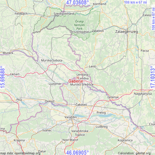
Gaberje GPS coordinates[2]
46° 33' 16.992" North, 16° 24' 0" East
| Map corner | latitude | longitude |
|---|---|---|
| Upper-left | 47.03608°, | 15.69688° |
| Center: | 46.55472°, | 16.4° |
| Lower-right: | 46.06905°, | 17.10313° |
| Map W x H: | 107.5×107.5 km | = 66.8×66.8mi |
| max Lat: | 46.83694° ⇑14.3% North |
| Gaberje: | 46.55472° |
| min Lat: | ⇓85.7% South 45.47667° |
| min Long | Gaberje | max Long |
| 13.52639° | 16.4° | 16.4975° |
| W 99.2%⇐ | ⇒0.8% E |
Elevation
Elevation of Gaberje is 163 m = 535 ft, and this is 162.6 m = 533 ft below average elevation for this country.
| Max E: |
1551 m = 5089 ft | 90.7% |
| Avg. | 325.6 m = 1068 ft | |
| Gaberje | 163 m = 535 ft | |
Min E: |
2 m = 7 ft | 9.3% |
See also: Slovenia elevation on elevation.city.
Geographical zone
Gaberje is located in North temperate zone (between Tropic of Cancer and the Arctic Circle). Distance of this North polar circle is 2224.8 km =1382.4 mi to North.| Distance of | km | miles | from Gaberje |
|---|---|---|---|
| North Pole | 4830.7 | 3001.7 | to North |
| Arctic Circle | 2224.8 | 1382.4 | to North |
| Tropic Cancer | 2570.5 | 1597.2 | to South |
| Equator | 5176.4 | 3216.5 | to South |


Nearby cities:
15 places around Gaberje: (largest is in red/bold)
• Dolga Vas
4.9 km =3 mi,  40°
40°
• Dolnja Bistrica
8.7 km =5.4 mi,  259°
259°
• Gomilica
8.6 km =5.3 mi,  308°
308°
• Hotiza
3.1 km =1.9 mi, 259°
• Lendava
4.1 km =2.5 mi,  73°
73°
• Lendavske Gorice
5.2 km =3.2 mi,  80°
80°
• Nedelica
8.6 km =5.3 mi,  323°
323°
• Odranci
9.8 km =6.1 mi,  291°
291°
• Petišovci
5.6 km =3.5 mi,  123°
123°
• Razkrižje
9.8 km =6.1 mi,  247°
247°
• Trnje
7.9 km =4.9 mi,  297°
297°
• Velika Polana
4.5 km =2.8 mi, 295°
• Čentiba
7.5 km =4.7 mi,  89°
89°
• Črenšovci
7.3 km =4.5 mi,  272°
272°
• Žižki
6.6 km =4.1 mi,  282°
282°
Sources, notices
• [Note1] Compared only with cities in Slovenia existing in our database
• [Src1] Map data: © OpenStreetMap contributors (CC-BY-SA)
• [Src2] Other city data from geonames.org with taken over terms of usage.
• [Src3] Geographical zone / Annual Mean Temperature by Robert A. Rohde @ Wikipedia
