Bohinjska Bistrica geodata
Bohinjska Bistrica (Bohinj) is a seat of a first-order administrative division; located in Slovenia in Europe/Ljubljana (GMT+2) time zone. With population of 1,799 people, there are 113 cities with bigger population in this country. Compared to other cities in Slovenia, 51.3% of cities are located further ↓South; 87.7% of cities are located further →East and 88.5% of cities have lower elevation than Bohinjska Bistrica. Note1


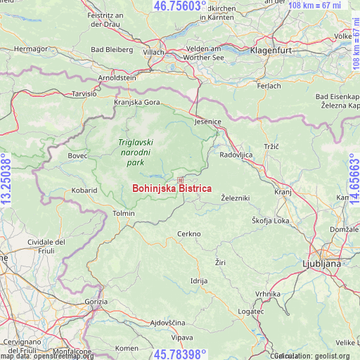
Bohinjska Bistrica GPS coordinates[2]
46° 16' 19.776" North, 13° 57' 12.6" East
| Map corner | latitude | longitude |
|---|---|---|
| Upper-left | 46.75603°, | 13.25038° |
| Center: | 46.27216°, | 13.9535° |
| Lower-right: | 45.78398°, | 14.65663° |
| Map W x H: | 108.1×108.1 km | = 67.2×67.2mi |
| max Lat: | 46.83694° ⇑48.7% North |
| Bohinjska Bistrica: | 46.27216° |
| min Lat: | ⇓51.3% South 45.47667° |
| min Long | Bohinjska Bistr | max Long |
| 13.52639° | 13.9535° | 16.4975° |
| W 12.3%⇐ | ⇒87.7% E |
Elevation
Elevation of Bohinjska Bistrica is 514 m = 1686 ft, and this is 188.4 m = 618 ft above average elevation for this country.
| Max E: |
1551 m = 5089 ft | 11.5% |
| Bohinjska Bistrica | 514 m 1686 ft | |
| Avg. | 325.6 m = 1068 ft | |
Min E: |
2 m = 7 ft | 88.5% |
See also: Slovenia elevation on elevation.city.
Geographical zone
Bohinjska Bistrica is located in North temperate zone (between Tropic of Cancer and the Arctic Circle). Distance of this North polar circle is 2256.2 km =1401.9 mi to North.| Distance of | km | miles | from Bohinjska Bistrica |
|---|---|---|---|
| North Pole | 4862.1 | 3021.2 | to North |
| Arctic Circle | 2256.2 | 1401.9 | to North |
| Tropic Cancer | 2539.1 | 1577.7 | to South |
| Equator | 5145 | 3197 | to South |


Nearby cities:
15 places around Bohinjska Bistrica: (largest is in red/bold)
• Bled
16.4 km =10.2 mi,  48°
48°
• Blejska Dobrava
18.1 km =11.2 mi,  38°
38°
• Bohinjska Bela
12 km =7.5 mi, 44°
• Cerkno
16.4 km =10.2 mi,  172°
172°
• Lesce
18.5 km =11.5 mi,  57°
57°
• Mojstrana
17.9 km =11.1 mi,  340°
340°
• Podbrdo
7 km =4.3 mi, 173°
• Radovljica
18.8 km =11.7 mi, 64°
• Ribno
13.5 km =8.4 mi, 62°
• Spodnje Gorje
16.9 km =10.5 mi,  21°
21°
• Srednja Vas v Bohinju
3.4 km =2.1 mi,  318°
318°
• Stara Fužina
10.2 km =6.3 mi,  304°
304°
• Zasip
17.9 km =11.1 mi, 41°
• Zgornje Gorje
14.9 km =9.3 mi, 36°
• Železniki
17.6 km =10.9 mi,  107°
107°
Sources, notices
• [Note1] Compared only with cities in Slovenia existing in our database
• [Src1] Map data: © OpenStreetMap contributors (CC-BY-SA)
• [Src2] Other city data from geonames.org with taken over terms of usage.
• [Src3] Geographical zone / Annual Mean Temperature by Robert A. Rohde @ Wikipedia
