Razkrižje geodata
Razkrižje is a seat of a first-order administrative division; located in Slovenia in Europe/Ljubljana (GMT+2) time zone. With population of 252 people, there are 586 cities with bigger population in this country. Compared to other cities in Slovenia, 80.8% of cities are located further ↓South; 96.3% of cities are located further ←West and 87.5% of cities have higher elevation than Razkrižje. Note1


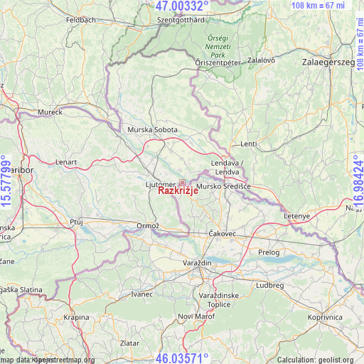
Razkrižje GPS coordinates[2]
46° 31' 18.012" North, 16° 16' 51.996" East
| Map corner | latitude | longitude |
|---|---|---|
| Upper-left | 47.00332°, | 15.57799° |
| Center: | 46.52167°, | 16.28111° |
| Lower-right: | 46.03571°, | 16.98424° |
| Map W x H: | 107.6×107.6 km | = 66.9×66.9mi |
| max Lat: | 46.83694° ⇑19.2% North |
| Razkrižje: | 46.52167° |
| min Lat: | ⇓80.8% South 45.47667° |
| min Long | Razkrižje | max Long |
| 13.52639° | 16.28111° | 16.4975° |
| W 96.3%⇐ | ⇒3.7% E |
Elevation
Elevation of Razkrižje is 173 m = 568 ft, and this is 152.6 m = 501 ft below average elevation for this country.
| Max E: |
1551 m = 5089 ft | 87.5% |
| Avg. | 325.6 m = 1068 ft | |
| Razkrižje | 173 m = 568 ft | |
Min E: |
2 m = 7 ft | 12.5% |
See also: Slovenia elevation on elevation.city.
Geographical zone
Razkrižje is located in North temperate zone (between Tropic of Cancer and the Arctic Circle). Distance of this North polar circle is 2228.4 km =1384.7 mi to North.| Distance of | km | miles | from Razkrižje |
|---|---|---|---|
| North Pole | 4834.3 | 3003.9 | to North |
| Arctic Circle | 2228.4 | 1384.7 | to North |
| Tropic Cancer | 2566.8 | 1594.9 | to South |
| Equator | 5172.7 | 3214.2 | to South |


Nearby cities:
15 places around Razkrižje: (largest is in red/bold)
• Cven
5.5 km =3.4 mi,  300°
300°
• Dolnja Bistrica
2.1 km =1.3 mi,  15°
15°
• Gaberje
9.8 km =6.1 mi,  67°
67°
• Gomilica
9.4 km =5.8 mi,  14°
14°
• Gornja Bistrica
5.1 km =3.2 mi,  347°
347°
• Hotiza
6.8 km =4.2 mi,  62°
62°
• Ižakovci
8.8 km =5.5 mi,  328°
328°
• Lipa
9.5 km =5.9 mi,  2°
2°
• Ljutomer
6.4 km =4 mi,  269°
269°
• Melinci
6.7 km =4.2 mi, 329°
• Odranci
7.2 km =4.5 mi,  359°
359°
• Trnje
7.6 km =4.7 mi, 15°
• Velika Polana
7.5 km =4.7 mi,  42°
42°
• Črenšovci
4.4 km =2.7 mi, 23°
• Žižki
5.7 km =3.5 mi,  27°
27°
Sources, notices
• [Note1] Compared only with cities in Slovenia existing in our database
• [Src1] Map data: © OpenStreetMap contributors (CC-BY-SA)
• [Src2] Other city data from geonames.org with taken over terms of usage.
• [Src3] Geographical zone / Annual Mean Temperature by Robert A. Rohde @ Wikipedia
