Leše geodata
Leše (Prevalje) is a populated place; located in Slovenia in Europe/Ljubljana (GMT+2) time zone. With population of 586 people, there are 448 cities with bigger population in this country. Compared to other cities in Slovenia, 81.5% of cities are located further ↓South; 52.8% of cities are located further →East and 92.8% of cities have lower elevation than Leše. Note1


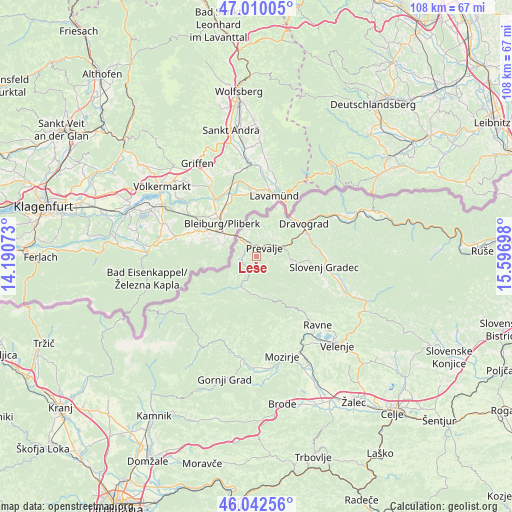
Leše GPS coordinates[2]
46° 31' 42.456" North, 14° 53' 37.86" East
| Map corner | latitude | longitude |
|---|---|---|
| Upper-left | 47.01005°, | 14.19073° |
| Center: | 46.52846°, | 14.89385° |
| Lower-right: | 46.04256°, | 15.59698° |
| Map W x H: | 107.6×107.6 km | = 66.9×66.9mi |
| max Lat: | 46.83694° ⇑18.5% North |
| Leše: | 46.52846° |
| min Lat: | ⇓81.5% South 45.47667° |
| min Long | Leše | max Long |
| 13.52639° | 14.89385° | 16.4975° |
| W 47.2%⇐ | ⇒52.8% E |
Elevation
Elevation of Leše is 566 m = 1857 ft, and this is 240.4 m = 789 ft above average elevation for this country.
| Max E: |
1551 m = 5089 ft | 7.2% |
| Leše | 566 m 1857 ft | |
| Avg. | 325.6 m = 1068 ft | |
Min E: |
2 m = 7 ft | 92.8% |
See also: Slovenia elevation on elevation.city.
Geographical zone
Leše is located in North temperate zone (between Tropic of Cancer and the Arctic Circle). Distance of this North polar circle is 2227.7 km =1384.2 mi to North.| Distance of | km | miles | from Leše |
|---|---|---|---|
| North Pole | 4833.6 | 3003.5 | to North |
| Arctic Circle | 2227.7 | 1384.2 | to North |
| Tropic Cancer | 2567.6 | 1595.4 | to South |
| Equator | 5173.5 | 3214.7 | to South |


Nearby cities:
15 places around Leše: (largest is in red/bold)
• Brdinje
8.1 km =5 mi,  86°
86°
• Dobja Vas
4.1 km =2.5 mi,  66°
66°
• Dravograd
11.6 km =7.2 mi,  55°
55°
• Kotlje
7.2 km =4.5 mi,  96°
96°
• Mežica
3.1 km =1.9 mi,  255°
255°
• Otiški Vrh
11.8 km =7.3 mi, 64°
• Pameče
14.2 km =8.8 mi, 87°
• Podgorje
15.8 km =9.8 mi,  113°
113°
• Prevalje
2.9 km =1.8 mi,  45°
45°
• Ravne na Koroškem
6 km =3.7 mi, 74°
• Slovenj Gradec
14.4 km =8.9 mi, 98°
• Stari Trg
13.6 km =8.5 mi, 103°
• Črna na Koroškem
7.3 km =4.5 mi,  207°
207°
• Črneče
10.6 km =6.6 mi, 50°
• Šentjanž pri Dravogradu
11.7 km =7.3 mi, 71°
Sources, notices
• [Note1] Compared only with cities in Slovenia existing in our database
• [Src1] Map data: © OpenStreetMap contributors (CC-BY-SA)
• [Src2] Other city data from geonames.org with taken over terms of usage.
• [Src3] Geographical zone / Annual Mean Temperature by Robert A. Rohde @ Wikipedia
