Vipava geodata
Vipava is a seat of a first-order administrative division; located in Slovenia in Europe/Ljubljana (GMT+2) time zone. With population of 1,771 people, there are 115 cities with bigger population in this country. Compared to other cities in Slovenia, 86.3% of cities are located further ↑North; 87.3% of cities are located further →East and 93.5% of cities have higher elevation than Vipava. Note1


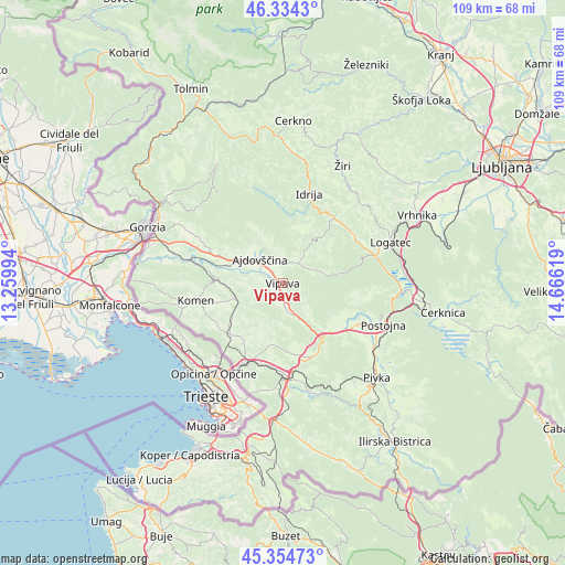
Vipava GPS coordinates[2]
45° 50' 48.012" North, 13° 57' 47.016" East
| Map corner | latitude | longitude |
|---|---|---|
| Upper-left | 46.3343°, | 13.25994° |
| Center: | 45.84667°, | 13.96306° |
| Lower-right: | 45.35473°, | 14.66619° |
| Map W x H: | 108.9×108.9 km | = 67.7×67.7mi |
| max Lat: | 46.83694° ⇑86.3% North |
| Vipava: | 45.84667° |
| min Lat: | ⇓13.7% South 45.47667° |
| min Long | Vipava | max Long |
| 13.52639° | 13.96306° | 16.4975° |
| W 12.7%⇐ | ⇒87.3% E |
Elevation
Elevation of Vipava is 110 m = 361 ft, and this is 215.6 m = 707 ft below average elevation for this country.
| Max E: |
1551 m = 5089 ft | 93.5% |
| Avg. | 325.6 m = 1068 ft | |
| Vipava | 110 m = 361 ft | |
Min E: |
2 m = 7 ft | 6.5% |
See also: Slovenia elevation on elevation.city.
Geographical zone
Vipava is located in North temperate zone (between Tropic of Cancer and the Arctic Circle). Distance of this North polar circle is 2303.5 km =1431.3 mi to North.| Distance of | km | miles | from Vipava |
|---|---|---|---|
| North Pole | 4909.4 | 3050.6 | to North |
| Arctic Circle | 2303.5 | 1431.3 | to North |
| Tropic Cancer | 2491.8 | 1548.3 | to South |
| Equator | 5097.7 | 3167.6 | to South |


Nearby cities:
15 places around Vipava: (largest is in red/bold)
• Ajdovščina
6 km =3.7 mi,  316°
316°
• Branik
13.9 km =8.6 mi,  274°
274°
• Budanje
3.3 km =2.1 mi,  339°
339°
• Cesta
8.6 km =5.3 mi,  302°
302°
• Divača
18 km =11.2 mi,  178°
178°
• Dutovlje
14.1 km =8.8 mi,  225°
225°
• Godovič
16 km =9.9 mi,  39°
39°
• Hotedršica
16.7 km =10.4 mi,  56°
56°
• Komen
17 km =10.6 mi,  258°
258°
• Križ
13.6 km =8.5 mi,  213°
213°
• Lokavec
8.9 km =5.5 mi,  313°
313°
• Senožeče
15.2 km =9.4 mi,  156°
156°
• Sežana
16.8 km =10.4 mi,  204°
204°
• Vrhpolje
2 km =1.2 mi,  356°
356°
• Črni Vrh
10.6 km =6.6 mi, 35°
Sources, notices
• [Note1] Compared only with cities in Slovenia existing in our database
• [Src1] Map data: © OpenStreetMap contributors (CC-BY-SA)
• [Src2] Other city data from geonames.org with taken over terms of usage.
• [Src3] Geographical zone / Annual Mean Temperature by Robert A. Rohde @ Wikipedia
