Budanje geodata
Budanje (Ajdovščina) is a populated place; located in Slovenia in Europe/Ljubljana (GMT+2) time zone. With population of 817 people, there are 286 cities with bigger population in this country. Compared to other cities in Slovenia, 85.3% of cities are located further ↑North; 87.8% of cities are located further →East and 69.2% of cities have higher elevation than Budanje. Note1


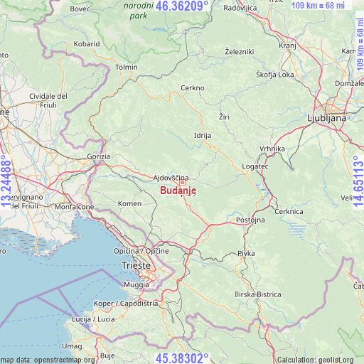
Budanje GPS coordinates[2]
45° 52' 28.956" North, 13° 56' 52.8" East
| Map corner | latitude | longitude |
|---|---|---|
| Upper-left | 46.36209°, | 13.24488° |
| Center: | 45.87471°, | 13.948° |
| Lower-right: | 45.38302°, | 14.65113° |
| Map W x H: | 108.9×108.9 km | = 67.7×67.7mi |
| max Lat: | 46.83694° ⇑85.3% North |
| Budanje: | 45.87471° |
| min Lat: | ⇓14.7% South 45.47667° |
| min Long | Budanje | max Long |
| 13.52639° | 13.948° | 16.4975° |
| W 12.2%⇐ | ⇒87.8% E |
Elevation
Elevation of Budanje is 245 m = 804 ft, and this is 80.6 m = 264 ft below average elevation for this country.
| Max E: |
1551 m = 5089 ft | 69.2% |
| Avg. | 325.6 m = 1068 ft | |
| Budanje | 245 m = 804 ft | |
Min E: |
2 m = 7 ft | 30.8% |
See also: Slovenia elevation on elevation.city.
Geographical zone
Budanje is located in North temperate zone (between Tropic of Cancer and the Arctic Circle). Distance of this North polar circle is 2300.4 km =1429.4 mi to North.| Distance of | km | miles | from Budanje |
|---|---|---|---|
| North Pole | 4906.3 | 3048.6 | to North |
| Arctic Circle | 2300.4 | 1429.4 | to North |
| Tropic Cancer | 2494.9 | 1550.3 | to South |
| Equator | 5100.8 | 3169.5 | to South |


Nearby cities:
15 places around Budanje: (largest is in red/bold)
• Ajdovščina
3.2 km =2 mi,  292°
292°
• Branik
12.8 km =8 mi,  261°
261°
• Cesta
6.2 km =3.9 mi,  283°
283°
• Dornberk
16.4 km =10.2 mi, 275°
• Dutovlje
15.8 km =9.8 mi,  214°
214°
• Godovič
14.6 km =9.1 mi,  50°
50°
• Hotedršica
16.2 km =10.1 mi,  67°
67°
• Idrija
15.6 km =9.7 mi,  24°
24°
• Komen
16.8 km =10.4 mi,  246°
246°
• Križ
15.8 km =9.8 mi,  203°
203°
• Lokavec
6.1 km =3.8 mi,  299°
299°
• Vipava
3.3 km =2.1 mi,  159°
159°
• Vitovlje
15.8 km =9.8 mi, 296°
• Vrhpolje
1.5 km =0.9 mi,  137°
137°
• Črni Vrh
9.2 km =5.7 mi, 53°
Sources, notices
• [Note1] Compared only with cities in Slovenia existing in our database
• [Src1] Map data: © OpenStreetMap contributors (CC-BY-SA)
• [Src2] Other city data from geonames.org with taken over terms of usage.
• [Src3] Geographical zone / Annual Mean Temperature by Robert A. Rohde @ Wikipedia
