Terchová geodata
Terchová (Žilinský kraj) is a populated place; located in Slovakia in Europe/Bratislava (GMT+2) time zone. With population of 4,073 people, there are 122 cities with bigger population in this country. Compared to other cities in Slovakia, 90.6% of cities are located further ↓South; 50.6% of cities are located further ←West and 77.6% of cities have lower elevation than Terchová. Note1


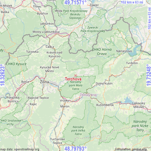
Terchová GPS coordinates[2]
49° 15' 32.22" North, 19° 1' 45.66" East
| Map corner | latitude | longitude |
|---|---|---|
| Upper-left | 49.71571°, | 18.32623° |
| Center: | 49.25895°, | 19.02935° |
| Lower-right: | 48.79793°, | 19.73248° |
| Map W x H: | 102×102 km | = 63.4×63.4mi |
| max Lat: | 49.43503° ⇑9.4% North |
| Terchová: | 49.25895° |
| min Lat: | ⇓90.6% South 47.76356° |
| min Long | Terchová | max Long |
| 16.9786° | 19.02935° | 22.18136° |
| W 50.6%⇐ | ⇒49.4% E |
Elevation
Elevation of Terchová is 512 m = 1680 ft, and this is 175.9 m = 577 ft above average elevation for this country.
| Max E: |
1006 m = 3301 ft | 22.4% |
| Terchová | 512 m 1680 ft | |
| Avg. | 336.1 m = 1103 ft | |
Min E: |
102 m = 335 ft | 77.6% |
See also: Slovakia elevation on elevation.city.
Geographical zone
Terchová is located in North temperate zone (between Tropic of Cancer and the Arctic Circle). Distance of this North polar circle is 1924.1 km =1195.6 mi to North.| Distance of | km | miles | from Terchová |
|---|---|---|---|
| North Pole | 4530 | 2814.8 | to North |
| Arctic Circle | 1924.1 | 1195.6 | to North |
| Tropic Cancer | 2871.2 | 1784.1 | to South |
| Equator | 5477.1 | 3403.3 | to South |


Nearby cities:
15 places around Terchová: (largest is in red/bold)
• Dolný Kubín
20.6 km =12.8 mi,  105°
105°
• Krasňany
11.4 km =7.1 mi,  244°
244°
• Krušetnica
25.9 km =16.1 mi,  60°
60°
• Kysucké Nové Mesto
18.4 km =11.4 mi,  284°
284°
• Lúčky
30.7 km =19.1 mi,  117°
117°
• Martin
22.7 km =14.1 mi,  199°
199°
• Oravská Lesná
16.3 km =10.1 mi,  42°
42°
• Oravský Podzámok
23.8 km =14.8 mi,  89°
89°
• Párnica
14.2 km =8.8 mi, 120°
• Ružomberok
28.8 km =17.9 mi,  135°
135°
• Stráža
9.6 km =6 mi,  247°
247°
• Turzovka
33.6 km =20.9 mi,  298°
298°
• Vrútky
18.1 km =11.2 mi,  206°
206°
• Čadca
26.2 km =16.3 mi,  318°
318°
• Žilina
21.4 km =13.3 mi,  259°
259°
Sources, notices
• [Note1] Compared only with cities in Slovakia existing in our database
• [Src1] Map data: © OpenStreetMap contributors (CC-BY-SA)
• [Src2] Other city data from geonames.org with taken over terms of usage.
• [Src3] Geographical zone / Annual Mean Temperature by Robert A. Rohde @ Wikipedia
