Turzovka geodata
Turzovka (Žilinský kraj) is a populated place; located in Slovakia in Europe/Bratislava (GMT+2) time zone. With population of 7,854 people, there are 83 cities with bigger population in this country. Compared to other cities in Slovakia, 98.8% of cities are located further ↓South; 62.9% of cities are located further →East and 74.1% of cities have lower elevation than Turzovka. Note1


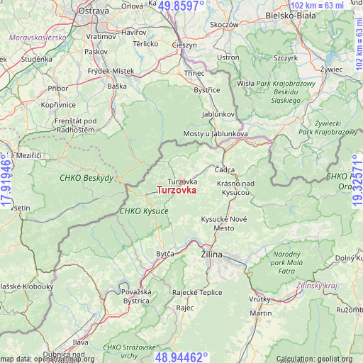
Turzovka GPS coordinates[2]
49° 24' 15.444" North, 18° 37' 21.288" East
| Map corner | latitude | longitude |
|---|---|---|
| Upper-left | 49.8597°, | 17.91946° |
| Center: | 49.40429°, | 18.62258° |
| Lower-right: | 48.94462°, | 19.32571° |
| Map W x H: | 101.7×101.7 km | = 63.2×63.2mi |
| max Lat: | 49.43503° ⇑1.2% North |
| Turzovka: | 49.40429° |
| min Lat: | ⇓98.8% South 47.76356° |
| min Long | Turzovka | max Long |
| 16.9786° | 18.62258° | 22.18136° |
| W 37.1%⇐ | ⇒62.9% E |
Elevation
Elevation of Turzovka is 472 m = 1549 ft, and this is 135.9 m = 446 ft above average elevation for this country.
| Max E: |
1006 m = 3301 ft | 25.9% |
| Turzovka | 472 m 1549 ft | |
| Avg. | 336.1 m = 1103 ft | |
Min E: |
102 m = 335 ft | 74.1% |
See also: Slovakia elevation on elevation.city.
Geographical zone
Turzovka is located in North temperate zone (between Tropic of Cancer and the Arctic Circle). Distance of this North polar circle is 1907.9 km =1185.5 mi to North.| Distance of | km | miles | from Turzovka |
|---|---|---|---|
| North Pole | 4513.8 | 2804.7 | to North |
| Arctic Circle | 1907.9 | 1185.5 | to North |
| Tropic Cancer | 2887.3 | 1794.1 | to South |
| Equator | 5493.2 | 3413.3 | to South |


Nearby cities:
15 places around Turzovka: (largest is in red/bold)
• Bytča
20.6 km =12.8 mi,  192°
192°
• Krasňany
28.5 km =17.7 mi,  137°
137°
• Krušetnica
51.9 km =32.2 mi,  93°
93°
• Kysucké Nové Mesto
16.4 km =10.2 mi,  134°
134°
• Martin
43.5 km =27 mi,  149°
149°
• Oravská Lesná
40.6 km =25.2 mi,  95°
95°
• Považská Bystrica
34.7 km =21.6 mi,  204°
204°
• Párnica
47.8 km =29.7 mi,  119°
119°
• Púchov
37.8 km =23.5 mi,  214°
214°
• Rajec
35.1 km =21.8 mi,  177°
177°
• Stráža
28.7 km =17.8 mi, 133°
• Terchová
33.6 km =20.9 mi, 118°
• Vrútky
38.8 km =24.1 mi, 146°
• Čadca
12.5 km =7.8 mi,  74°
74°
• Žilina
21.8 km =13.5 mi,  157°
157°
Sources, notices
• [Note1] Compared only with cities in Slovakia existing in our database
• [Src1] Map data: © OpenStreetMap contributors (CC-BY-SA)
• [Src2] Other city data from geonames.org with taken over terms of usage.
• [Src3] Geographical zone / Annual Mean Temperature by Robert A. Rohde @ Wikipedia
