Párnica geodata
Párnica (Žilinský kraj) is a populated place; located in Slovakia in Europe/Bratislava (GMT+2) time zone. With population of 807 people, there are 158 cities with bigger population in this country. Compared to other cities in Slovakia, 85.9% of cities are located further ↓South; 54.1% of cities are located further ←West and 71.8% of cities have lower elevation than Párnica. Note1


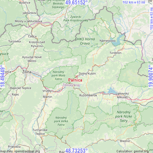
Párnica GPS coordinates[2]
49° 11' 38.976" North, 19° 11' 51.396" East
| Map corner | latitude | longitude |
|---|---|---|
| Upper-left | 49.65152°, | 18.49449° |
| Center: | 49.19416°, | 19.19761° |
| Lower-right: | 48.73253°, | 19.90074° |
| Map W x H: | 102.2×102.2 km | = 63.5×63.5mi |
| max Lat: | 49.43503° ⇑14.1% North |
| Párnica: | 49.19416° |
| min Lat: | ⇓85.9% South 47.76356° |
| min Long | Párnica | max Long |
| 16.9786° | 19.19761° | 22.18136° |
| W 54.1%⇐ | ⇒45.9% E |
Elevation
Elevation of Párnica is 454 m = 1490 ft, and this is 117.9 m = 387 ft above average elevation for this country.
| Max E: |
1006 m = 3301 ft | 28.2% |
| Párnica | 454 m 1490 ft | |
| Avg. | 336.1 m = 1103 ft | |
Min E: |
102 m = 335 ft | 71.8% |
See also: Slovakia elevation on elevation.city.
Geographical zone
Párnica is located in North temperate zone (between Tropic of Cancer and the Arctic Circle). Distance of this North polar circle is 1931.3 km =1200.1 mi to North.| Distance of | km | miles | from Párnica |
|---|---|---|---|
| North Pole | 4537.2 | 2819.3 | to North |
| Arctic Circle | 1931.3 | 1200.1 | to North |
| Tropic Cancer | 2864 | 1779.6 | to South |
| Equator | 5469.9 | 3398.8 | to South |


Nearby cities:
15 places around Párnica: (largest is in red/bold)
• Bešeňová
20.2 km =12.6 mi,  121°
121°
• Dolný Kubín
7.9 km =4.9 mi,  77°
77°
• Krasňany
22.7 km =14.1 mi,  275°
275°
• Krušetnica
22.6 km =14 mi,  26°
26°
• Liptovská Sielnica
23.7 km =14.7 mi,  103°
103°
• Liptovský Trnovec
26.7 km =16.6 mi,  107°
107°
• Lúčky
16.5 km =10.3 mi, 115°
• Martin
24.4 km =15.2 mi,  234°
234°
• Nižná
27 km =16.8 mi,  61°
61°
• Oravská Lesná
19.2 km =11.9 mi,  356°
356°
• Oravský Podzámok
13.7 km =8.5 mi, 57°
• Ružomberok
15.5 km =9.6 mi,  148°
148°
• Stráža
21.3 km =13.2 mi, 279°
• Terchová
14.2 km =8.8 mi,  300°
300°
• Vrútky
22.3 km =13.9 mi,  246°
246°
Sources, notices
• [Note1] Compared only with cities in Slovakia existing in our database
• [Src1] Map data: © OpenStreetMap contributors (CC-BY-SA)
• [Src2] Other city data from geonames.org with taken over terms of usage.
• [Src3] Geographical zone / Annual Mean Temperature by Robert A. Rohde @ Wikipedia
