Santo Tomás geodata
Santo Tomás (San Salvador) is a populated place; located in El Salvador in America/El_Salvador (GMT-6) time zone. With population of 14,581 people, there are 36 cities with bigger population in this country. Compared to other cities in El Salvador, 62% of cities are located further ↑North; 55% of cities are located further →East and 80% of cities have lower elevation than Santo Tomás. Note1


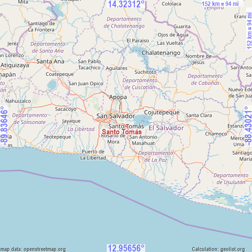
Santo Tomás GPS coordinates[2]
13° 38' 26.988" North, 89° 7' 59.988" West
| Map corner | latitude | longitude |
|---|---|---|
| Upper-left | 14.32312°, | -89.83646° |
| Center: | 13.64083°, | -89.13333° |
| Lower-right: | 12.95656°, | -88.43021° |
| Map W x H: | 151.9×151.9 km | = 94.4×94.4mi |
| max Lat: | 14.33333° ⇑62% North |
| Santo Tomás: | 13.64083° |
| min Lat: | ⇓38% South 13.19694° |
| min Long | Santo Tomás | max Long |
| -90.01583° | -89.13333° | -87.83861° |
| W 45%⇐ | ⇒55% E |
Elevation
Elevation of Santo Tomás is 712 m = 2336 ft, and this is 240.1 m = 788 ft above average elevation for this country.
| Max E: |
1255 m = 4117 ft | 20% |
| Santo Tomás | 712 m 2336 ft | |
| Avg. | 471.9 m = 1548 ft | |
Min E: |
13 m = 43 ft | 80% |
See also: El Salvador elevation on elevation.city.
Geographical zone
Santo Tomás is located in North Torrid zone (between Equator and Tropic of Cancer). Distance of this Northern Tropic circle is 1089.2 km =676.8 mi to North.| Distance of | km | miles | from Santo Tomás |
|---|---|---|---|
| North Pole | 8490.3 | 5275.6 | to North |
| Arctic Circle | 5884.5 | 3656.5 | to North |
| Tropic Cancer | 1089.2 | 676.8 | to North |
| Equator | 1516.7 | 942.4 | to South |


Nearby cities:
15 places around Santo Tomás: (largest is in red/bold)
• Antiguo Cuscatlán
13.2 km =8.2 mi,  281°
281°
• Ayutuxtepeque
14.1 km =8.8 mi,  325°
325°
• Cuscatancingo
11.8 km =7.3 mi, 333°
• Delgado
10.1 km =6.3 mi,  336°
336°
• Ilopango
7.2 km =4.5 mi,  20°
20°
• Mejicanos
14 km =8.7 mi,  322°
322°
• Nuevo Cuscatlán
14.3 km =8.9 mi,  273°
273°
• Olocuilta
8.1 km =5 mi,  167°
167°
• Panchimalco
5.9 km =3.7 mi,  238°
238°
• Rosario de Mora
10.9 km =6.8 mi,  228°
228°
• San Marcos
5.7 km =3.5 mi,  290°
290°
• San Pedro Masahuat
14.9 km =9.3 mi,  136°
136°
• San Salvador
7.9 km =4.9 mi,  312°
312°
• Soyapango
7.8 km =4.8 mi,  354°
354°
• Tonacatepeque
15.7 km =9.8 mi,  5°
5°
Sources, notices
• [Note1] Compared only with cities in El Salvador existing in our database
• [Src1] Map data: © OpenStreetMap contributors (CC-BY-SA)
• [Src2] Other city data from geonames.org with taken over terms of usage.
• [Src3] Geographical zone / Annual Mean Temperature by Robert A. Rohde @ Wikipedia
