Nuevo Cuscatlán geodata
Nuevo Cuscatlán (La Libertad) is a populated place; located in El Salvador in America/El_Salvador (GMT-6) time zone. With population of 6,469 people, there are 58 cities with bigger population in this country. Compared to other cities in El Salvador, 61% of cities are located further ↑North; 70% of cities are located further →East and 96% of cities have lower elevation than Nuevo Cuscatlán. Note1


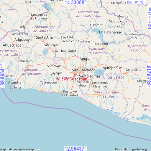
Nuevo Cuscatlán GPS coordinates[2]
13° 38' 54.996" North, 89° 15' 55.008" West
| Map corner | latitude | longitude |
|---|---|---|
| Upper-left | 14.33088°, | -89.96841° |
| Center: | 13.64861°, | -89.26528° |
| Lower-right: | 12.96437°, | -88.56216° |
| Map W x H: | 151.9×151.9 km | = 94.4×94.4mi |
| max Lat: | 14.33333° ⇑61% North |
| Nuevo Cuscatlán: | 13.64861° |
| min Lat: | ⇓39% South 13.19694° |
| min Long | Nuevo Cuscatlá | max Long |
| -90.01583° | -89.26528° | -87.83861° |
| W 30%⇐ | ⇒70% E |
Elevation
Elevation of Nuevo Cuscatlán is 906 m = 2972 ft, and this is 434.1 m = 1424 ft above average elevation for this country.
| Max E: |
1255 m = 4117 ft | 4% |
| Nuevo Cuscatlán | 906 m 2972 ft | |
| Avg. | 471.9 m = 1548 ft | |
Min E: |
13 m = 43 ft | 96% |
See also: El Salvador elevation on elevation.city.
Geographical zone
Nuevo Cuscatlán is located in North Torrid zone (between Equator and Tropic of Cancer). Distance of this Northern Tropic circle is 1088.3 km =676.2 mi to North.| Distance of | km | miles | from Nuevo Cuscatlán |
|---|---|---|---|
| North Pole | 8489.5 | 5275.1 | to North |
| Arctic Circle | 5883.6 | 3655.9 | to North |
| Tropic Cancer | 1088.3 | 676.2 | to North |
| Equator | 1517.6 | 943 | to South |


Nearby cities:
15 places around Nuevo Cuscatlán: (largest is in red/bold)
• Antiguo Cuscatlán
2.2 km =1.4 mi,  35°
35°
• Ayutuxtepeque
12.5 km =7.8 mi,  30°
30°
• Cuscatancingo
13.3 km =8.3 mi, 42°
• Delgado
13.3 km =8.3 mi,  50°
50°
• Ilopango
17.8 km =11.1 mi,  70°
70°
• Mejicanos
11.6 km =7.2 mi, 28°
• Olocuilta
18.2 km =11.3 mi,  118°
118°
• Panchimalco
10 km =6.2 mi,  113°
113°
• Rosario de Mora
10.2 km =6.3 mi,  143°
143°
• San Marcos
9 km =5.6 mi,  82°
82°
• San Salvador
9.6 km =6 mi,  61°
61°
• Santa Tecla
3.5 km =2.2 mi,  333°
333°
• Santo Tomás
14.3 km =8.9 mi,  93°
93°
• Soyapango
15.2 km =9.4 mi, 63°
• Zaragoza
7.1 km =4.4 mi,  201°
201°
Sources, notices
• [Note1] Compared only with cities in El Salvador existing in our database
• [Src1] Map data: © OpenStreetMap contributors (CC-BY-SA)
• [Src2] Other city data from geonames.org with taken over terms of usage.
• [Src3] Geographical zone / Annual Mean Temperature by Robert A. Rohde @ Wikipedia
