Soyapango geodata
Soyapango (San Salvador) is a populated place; located in El Salvador in America/El_Salvador (GMT-6) time zone. With population of 329,708 people, there is 1 city with bigger population in this country. Compared to other cities in El Salvador, 51% of cities are located further ↑North; 56% of cities are located further →East and 69% of cities have lower elevation than Soyapango. Note1


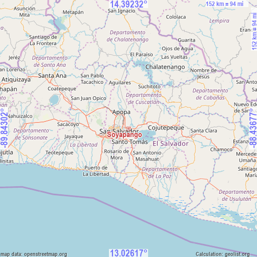
Soyapango GPS coordinates[2]
13° 42' 36.864" North, 89° 8' 23.604" West
| Map corner | latitude | longitude |
|---|---|---|
| Upper-left | 14.39232°, | -89.84302° |
| Center: | 13.71024°, | -89.13989° |
| Lower-right: | 13.02617°, | -88.43677° |
| Map W x H: | 151.9×151.9 km | = 94.4×94.4mi |
| max Lat: | 14.33333° ⇑51% North |
| Soyapango: | 13.71024° |
| min Lat: | ⇓49% South 13.19694° |
| min Long | Soyapango | max Long |
| -90.01583° | -89.13989° | -87.83861° |
| W 44%⇐ | ⇒56% E |
Elevation
Elevation of Soyapango is 634 m = 2080 ft, and this is 162.1 m = 532 ft above average elevation for this country.
| Max E: |
1255 m = 4117 ft | 31% |
| Soyapango | 634 m 2080 ft | |
| Avg. | 471.9 m = 1548 ft | |
Min E: |
13 m = 43 ft | 69% |
See also: Soyapango elevation on elevation.city.
Geographical zone
Soyapango is located in North Torrid zone (between Equator and Tropic of Cancer). Distance of this Northern Tropic circle is 1081.5 km =672 mi to North.| Distance of | km | miles | from Soyapango |
|---|---|---|---|
| North Pole | 8482.6 | 5270.8 | to North |
| Arctic Circle | 5876.7 | 3651.6 | to North |
| Tropic Cancer | 1081.5 | 672 | to North |
| Equator | 1524.4 | 947.2 | to South |


Nearby cities:
15 places around Soyapango: (largest is in red/bold)
• Antiguo Cuscatlán
13.2 km =8.2 mi,  247°
247°
• Apopa
11.6 km =7.2 mi,  338°
338°
• Ayutuxtepeque
8.2 km =5.1 mi,  298°
298°
• Cuscatancingo
5.3 km =3.3 mi, 302°
• Delgado
3.6 km =2.2 mi, 295°
• Ilopango
3.4 km =2.1 mi,  106°
106°
• Mejicanos
8.6 km =5.3 mi,  292°
292°
• Nuevo Cuscatlán
15.2 km =9.4 mi,  243°
243°
• Olocuilta
15.8 km =9.8 mi,  171°
171°
• Panchimalco
11.7 km =7.3 mi,  201°
201°
• San Marcos
7.4 km =4.6 mi,  219°
219°
• San Salvador
5.6 km =3.5 mi, 245°
• Santa Tecla
15.6 km =9.7 mi,  256°
256°
• Santo Tomás
7.8 km =4.8 mi, 174°
• Tonacatepeque
8.2 km =5.1 mi,  16°
16°
Sources, notices
• [Note1] Compared only with cities in El Salvador existing in our database
• [Src1] Map data: © OpenStreetMap contributors (CC-BY-SA)
• [Src2] Other city data from geonames.org with taken over terms of usage.
• [Src3] Geographical zone / Annual Mean Temperature by Robert A. Rohde @ Wikipedia
