Quezaltepeque geodata
Quezaltepeque (La Libertad) is a populated place; located in El Salvador in America/El_Salvador (GMT-6) time zone. With population of 28,886 people, there are 20 cities with bigger population in this country. Compared to other cities in El Salvador, 74% of cities are located further ↓South; 71% of cities are located further →East and 53% of cities have higher elevation than Quezaltepeque. Note1


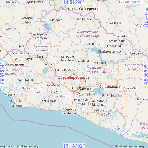
Quezaltepeque GPS coordinates[2]
13° 49' 52.464" North, 89° 16' 19.956" West
| Map corner | latitude | longitude |
|---|---|---|
| Upper-left | 14.51296°, | -89.97534° |
| Center: | 13.83124°, | -89.27221° |
| Lower-right: | 13.14752°, | -88.56909° |
| Map W x H: | 151.8×151.8 km | = 94.3×94.3mi |
| max Lat: | 14.33333° ⇑26% North |
| Quezaltepeque: | 13.83124° |
| min Lat: | ⇓74% South 13.19694° |
| min Long | Quezaltepeque | max Long |
| -90.01583° | -89.27221° | -87.83861° |
| W 29%⇐ | ⇒71% E |
Elevation
Elevation of Quezaltepeque is 443 m = 1453 ft, and this is 28.9 m = 95 ft below average elevation for this country.
| Max E: |
1255 m = 4117 ft | 53% |
| Avg. | 471.9 m = 1548 ft | |
| Quezaltepeque | 443 m = 1453 ft | |
Min E: |
13 m = 43 ft | 47% |
See also: El Salvador elevation on elevation.city.
Geographical zone
Quezaltepeque is located in North Torrid zone (between Equator and Tropic of Cancer). Distance of this Northern Tropic circle is 1068 km =663.6 mi to North.| Distance of | km | miles | from Quezaltepeque |
|---|---|---|---|
| North Pole | 8469.2 | 5262.5 | to North |
| Arctic Circle | 5863.3 | 3643.3 | to North |
| Tropic Cancer | 1068 | 663.6 | to North |
| Equator | 1537.9 | 955.6 | to South |


Nearby cities:
15 places around Quezaltepeque: (largest is in red/bold)
• Aguilares
16.6 km =10.3 mi,  32°
32°
• Antiguo Cuscatlán
18.6 km =11.6 mi,  173°
173°
• Apopa
10.4 km =6.5 mi,  104°
104°
• Ayutuxtepeque
11.9 km =7.4 mi,  143°
143°
• Ciudad Arce
18.9 km =11.7 mi,  273°
273°
• Cuscatancingo
14.4 km =8.9 mi, 137°
• Delgado
16.2 km =10.1 mi, 137°
• El Paisnal
16.9 km =10.5 mi,  20°
20°
• Guazapa
11.8 km =7.3 mi,  64°
64°
• Mejicanos
12 km =7.5 mi,  147°
147°
• San Juan Opico
10.7 km =6.6 mi,  297°
297°
• San Pablo Tacachico
17.6 km =10.9 mi,  335°
335°
• San Salvador
18.3 km =11.4 mi, 149°
• Santa Tecla
17.2 km =10.7 mi,  182°
182°
• Tonacatepeque
17.5 km =10.9 mi,  108°
108°
Sources, notices
• [Note1] Compared only with cities in El Salvador existing in our database
• [Src1] Map data: © OpenStreetMap contributors (CC-BY-SA)
• [Src2] Other city data from geonames.org with taken over terms of usage.
• [Src3] Geographical zone / Annual Mean Temperature by Robert A. Rohde @ Wikipedia
