Apopa geodata
Apopa (San Salvador) is a populated place; located in El Salvador in America/El_Salvador (GMT-6) time zone. With population of 112,158 people, there are 6 cities with bigger population in this country. Compared to other cities in El Salvador, 72% of cities are located further ↓South; 59% of cities are located further →East and 55% of cities have higher elevation than Apopa. Note1


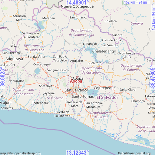
Apopa GPS coordinates[2]
13° 48' 25.992" North, 89° 10' 45.012" West
| Map corner | latitude | longitude |
|---|---|---|
| Upper-left | 14.48901°, | -89.8823° |
| Center: | 13.80722°, | -89.17917° |
| Lower-right: | 13.12343°, | -88.47605° |
| Map W x H: | 151.8×151.8 km | = 94.3×94.3mi |
| max Lat: | 14.33333° ⇑28% North |
| Apopa: | 13.80722° |
| min Lat: | ⇓72% South 13.19694° |
| min Long | Apopa | max Long |
| -90.01583° | -89.17917° | -87.83861° |
| W 41%⇐ | ⇒59% E |
Elevation
Elevation of Apopa is 434 m = 1424 ft, and this is 37.9 m = 124 ft below average elevation for this country.
| Max E: |
1255 m = 4117 ft | 55% |
| Avg. | 471.9 m = 1548 ft | |
| Apopa | 434 m = 1424 ft | |
Min E: |
13 m = 43 ft | 45% |
See also: Apopa elevation on elevation.city.
Geographical zone
Apopa is located in North Torrid zone (between Equator and Tropic of Cancer). Distance of this Northern Tropic circle is 1070.7 km =665.3 mi to North.| Distance of | km | miles | from Apopa |
|---|---|---|---|
| North Pole | 8471.8 | 5264.1 | to North |
| Arctic Circle | 5866 | 3645 | to North |
| Tropic Cancer | 1070.7 | 665.3 | to North |
| Equator | 1535.2 | 953.9 | to South |


Nearby cities:
15 places around Apopa: (largest is in red/bold)
• Aguilares
16.7 km =10.4 mi,  356°
356°
• Antiguo Cuscatlán
17.7 km =11 mi,  206°
206°
• Ayutuxtepeque
7.5 km =4.7 mi,  203°
203°
• Cuscatancingo
7.9 km =4.9 mi,  181°
181°
• Delgado
9.3 km =5.8 mi,  174°
174°
• Guazapa
7.8 km =4.8 mi,  4°
4°
• Ilopango
13.9 km =8.6 mi,  147°
147°
• Mejicanos
8.3 km =5.2 mi, 206°
• Quezaltepeque
10.4 km =6.5 mi,  284°
284°
• San Marcos
16.5 km =10.3 mi, 181°
• San Salvador
13.1 km =8.1 mi, 183°
• Santa Tecla
18.1 km =11.2 mi,  216°
216°
• Soyapango
11.6 km =7.2 mi,  158°
158°
• Tecoluca
18.9 km =11.7 mi,  96°
96°
• Tonacatepeque
7.2 km =4.5 mi,  113°
113°
Sources, notices
• [Note1] Compared only with cities in El Salvador existing in our database
• [Src1] Map data: © OpenStreetMap contributors (CC-BY-SA)
• [Src2] Other city data from geonames.org with taken over terms of usage.
• [Src3] Geographical zone / Annual Mean Temperature by Robert A. Rohde @ Wikipedia
