Metapán geodata
Metapán (Santa Ana) is a populated place; located in El Salvador in America/El_Salvador (GMT-6) time zone. With population of 19,143 people, there are 28 cities with bigger population in this country. Compared to other cities in El Salvador, 100% of cities are located further ↓South; 79% of cities are located further →East and 52% of cities have higher elevation than Metapán. Note1


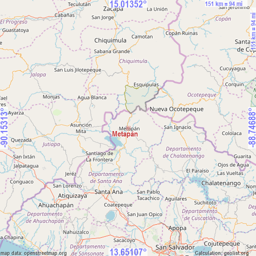
Metapán GPS coordinates[2]
14° 19' 59.988" North, 89° 27' 0" West
| Map corner | latitude | longitude |
|---|---|---|
| Upper-left | 15.01352°, | -90.15313° |
| Center: | 14.33333°, | -89.45° |
| Lower-right: | 13.65107°, | -88.74688° |
| Map W x H: | 151.5×151.5 km | = 94.1×94.1mi |
| max Lat: | 14.33333° ⇑0% North |
| Metapán: | 14.33333° |
| min Lat: | ⇓100% South 13.19694° |
| min Long | Metapán | max Long |
| -90.01583° | -89.45° | -87.83861° |
| W 21%⇐ | ⇒79% E |
Elevation
Elevation of Metapán is 471 m = 1545 ft, and this is 0.89999999999998 m = 3 ft below average elevation for this country.
| Max E: |
1255 m = 4117 ft | 52% |
| Avg. | 471.9 m = 1548 ft | |
| Metapán | 471 m = 1545 ft | |
Min E: |
13 m = 43 ft | 48% |
See also: El Salvador elevation on elevation.city.
Geographical zone
Metapán is located in North Torrid zone (between Equator and Tropic of Cancer). Distance of this Northern Tropic circle is 1012.2 km =629 mi to North.| Distance of | km | miles | from Metapán |
|---|---|---|---|
| North Pole | 8413.3 | 5227.8 | to North |
| Arctic Circle | 5807.5 | 3608.6 | to North |
| Tropic Cancer | 1012.2 | 629 | to North |
| Equator | 1593.7 | 990.3 | to South |


Nearby cities:
15 places around Metapán: (largest is in red/bold)
• Aguilares
50.4 km =31.3 mi,  146°
146°
• Atiquizaya
51.3 km =31.9 mi,  219°
219°
• Candelaria de La Frontera
32.3 km =20.1 mi, 221°
• Chalchuapa
45.9 km =28.5 mi,  212°
212°
• Ciudad Arce
54.8 km =34.1 mi,  179°
179°
• Coatepeque
45.4 km =28.2 mi,  187°
187°
• El Congo
47.5 km =29.5 mi, 185°
• El Paisnal
47.1 km =29.3 mi, 148°
• Guazapa
58.9 km =36.6 mi, 149°
• Nueva Concepción
27.5 km =17.1 mi,  143°
143°
• San Francisco Morazán
46.2 km =28.7 mi,  111°
111°
• San Juan Opico
51.8 km =32.2 mi,  169°
169°
• San Pablo Tacachico
41.5 km =25.8 mi,  163°
163°
• Santa Ana
39.5 km =24.5 mi,  197°
197°
• Texistepeque
22.9 km =14.2 mi, 193°
Sources, notices
• [Note1] Compared only with cities in El Salvador existing in our database
• [Src1] Map data: © OpenStreetMap contributors (CC-BY-SA)
• [Src2] Other city data from geonames.org with taken over terms of usage.
• [Src3] Geographical zone / Annual Mean Temperature by Robert A. Rohde @ Wikipedia
