Coatepeque geodata
Coatepeque (Santa Ana) is a populated place; located in El Salvador in America/El_Salvador (GMT-6) time zone. With population of 5,773 people, there are 66 cities with bigger population in this country. Compared to other cities in El Salvador, 86% of cities are located further ↓South; 83% of cities are located further →East and 86% of cities have lower elevation than Coatepeque. Note1


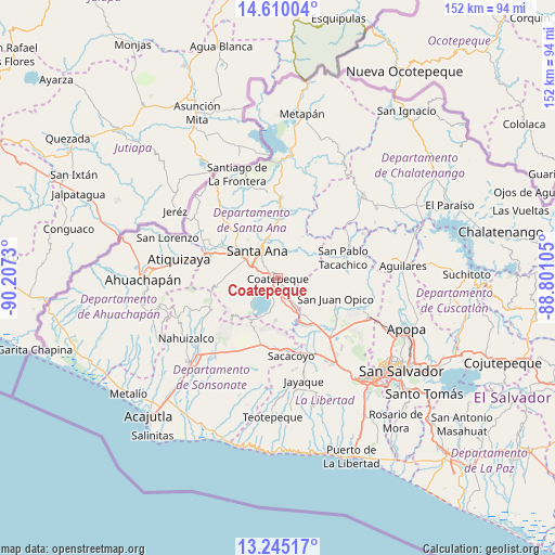
Coatepeque GPS coordinates[2]
13° 55' 42.996" North, 89° 30' 15.012" West
| Map corner | latitude | longitude |
|---|---|---|
| Upper-left | 14.61004°, | -90.2073° |
| Center: | 13.92861°, | -89.50417° |
| Lower-right: | 13.24517°, | -88.80105° |
| Map W x H: | 151.8×151.8 km | = 94.3×94.3mi |
| max Lat: | 14.33333° ⇑14% North |
| Coatepeque: | 13.92861° |
| min Lat: | ⇓86% South 13.19694° |
| min Long | Coatepeque | max Long |
| -90.01583° | -89.50417° | -87.83861° |
| W 17%⇐ | ⇒83% E |
Elevation
Elevation of Coatepeque is 756 m = 2480 ft, and this is 284.1 m = 932 ft above average elevation for this country.
| Max E: |
1255 m = 4117 ft | 14% |
| Coatepeque | 756 m 2480 ft | |
| Avg. | 471.9 m = 1548 ft | |
Min E: |
13 m = 43 ft | 86% |
See also: El Salvador elevation on elevation.city.
Geographical zone
Coatepeque is located in North Torrid zone (between Equator and Tropic of Cancer). Distance of this Northern Tropic circle is 1057.2 km =656.9 mi to North.| Distance of | km | miles | from Coatepeque |
|---|---|---|---|
| North Pole | 8458.3 | 5255.7 | to North |
| Arctic Circle | 5852.5 | 3636.6 | to North |
| Tropic Cancer | 1057.2 | 656.9 | to North |
| Equator | 1548.7 | 962.3 | to South |


Nearby cities:
15 places around Coatepeque: (largest is in red/bold)
• Armenia
20.6 km =12.8 mi,  178°
178°
• Atiquizaya
27.3 km =17 mi,  281°
281°
• Candelaria de La Frontera
26.2 km =16.3 mi,  323°
323°
• Chalchuapa
20.2 km =12.6 mi,  288°
288°
• Ciudad Arce
11.6 km =7.2 mi,  147°
147°
• El Congo
2.4 km =1.5 mi,  157°
157°
• El Paisnal
31.2 km =19.4 mi,  80°
80°
• Izalco
27.4 km =17 mi,  221°
221°
• Juayúa
27.8 km =17.3 mi,  249°
249°
• Nahuizalco
30.2 km =18.8 mi,  236°
236°
• Quezaltepeque
27.3 km =17 mi,  113°
113°
• San Juan Opico
16.6 km =10.3 mi, 110°
• San Pablo Tacachico
18.5 km =11.5 mi,  73°
73°
• Santa Ana
9.4 km =5.8 mi, 320°
• Texistepeque
22.8 km =14.2 mi,  1°
1°
Sources, notices
• [Note1] Compared only with cities in El Salvador existing in our database
• [Src1] Map data: © OpenStreetMap contributors (CC-BY-SA)
• [Src2] Other city data from geonames.org with taken over terms of usage.
• [Src3] Geographical zone / Annual Mean Temperature by Robert A. Rohde @ Wikipedia
