Bdāmā geodata
Bdāmā (Idlib) is a seat of a third-order administrative division; located in Syria in Asia/Damascus (GMT+3) time zone. In our database, there are 87 cities with bigger population. Compared to other cities in Syria, 71% of cities are located further ↓South; 76% of cities are located further →East and 56.5% of cities have higher elevation than Bdāmā. Note1


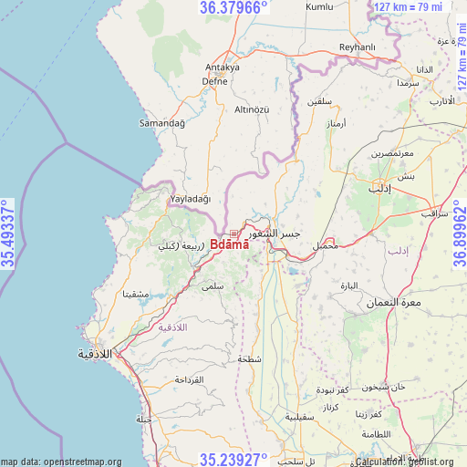
Bdāmā GPS coordinates[2]
35° 48' 41.436" North, 36° 11' 47.364" East
| Map corner | latitude | longitude |
|---|---|---|
| Upper-left | 36.37966°, | 35.49337° |
| Center: | 35.81151°, | 36.19649° |
| Lower-right: | 35.23927°, | 36.89962° |
| Map W x H: | 126.8×126.8 km | = 78.8×78.8mi |
| max Lat: | 37.17701° ⇑29% North |
| Bdāmā: | 35.81151° |
| min Lat: | ⇓71% South 32.39332° |
| min Long | Bdāmā | max Long |
| 35.75572° | 36.19649° | 42.14006° |
| W 24%⇐ | ⇒76% E |
Elevation
Elevation of Bdāmā is 434 m = 1424 ft, and this is 95.1 m = 312 ft below average elevation for this country.
| Max E: |
1640 m = 5381 ft | 56.5% |
| Avg. | 529.1 m = 1736 ft | |
| Bdāmā | 434 m = 1424 ft | |
Min E: |
4 m = 13 ft | 43.5% |
See also: Syria elevation on elevation.city.
Geographical zone
Bdāmā is located in North temperate zone (between Tropic of Cancer and the Arctic Circle). Distance of this Northern Tropic circle is 1375.9 km =854.9 mi to South.| Distance of | km | miles | from Bdāmā |
|---|---|---|---|
| North Pole | 6025.2 | 3743.9 | to North |
| Arctic Circle | 3419.3 | 2124.7 | to North |
| Tropic Cancer | 1375.9 | 854.9 | to South |
| Equator | 3981.9 | 2474.2 | to South |


Nearby cities:
15 places around Bdāmā: (largest is in red/bold)
• Al Bahlūlīyah
28.8 km =17.9 mi,  227°
227°
• Al Jānūdīyah
11.8 km =7.3 mi,  46°
46°
• Al Muzayri‘ah
33.1 km =20.6 mi,  200°
200°
• Al Ḩaffah
28.1 km =17.5 mi,  212°
212°
• Az Ziyārah
19.1 km =11.9 mi,  137°
137°
• Darkūsh
26.8 km =16.7 mi,  41°
41°
• Jisr ash Shughūr
11.1 km =6.9 mi,  88°
88°
• Kassab
22.6 km =14 mi,  304°
304°
• Kinnsibbā
8 km =5 mi, 201°
• Muḩambal
25 km =15.5 mi,  96°
96°
• Qasţal Ma‘āf
22.1 km =13.7 mi,  273°
273°
• Rabī‘ah
14.5 km =9 mi,  258°
258°
• Şlinfah
23.7 km =14.7 mi,  181°
181°
• ‘Ayn al Bayḑā
32.7 km =20.3 mi,  238°
238°
• ‘Ayn at Tīnah
28.8 km =17.9 mi, 197°
Sources, notices
• [Note1] Compared only with cities in Syria existing in our database
• [Src1] Map data: © OpenStreetMap contributors (CC-BY-SA)
• [Src2] Other city data from geonames.org with taken over terms of usage.
• [Src3] Geographical zone / Annual Mean Temperature by Robert A. Rohde @ Wikipedia
