Az Ziyārah geodata
Az Ziyārah (Hama) is a seat of a third-order administrative division; located in Syria in Asia/Damascus (GMT+3) time zone. In our database, there are 87 cities with bigger population. Compared to other cities in Syria, 67.5% of cities are located further ↓South; 66.8% of cities are located further →East and 95.1% of cities have higher elevation than Az Ziyārah. Note1


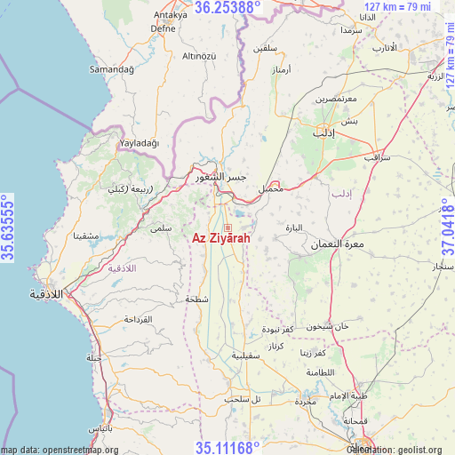
Az Ziyārah GPS coordinates[2]
35° 41' 5.352" North, 36° 20' 19.212" East
| Map corner | latitude | longitude |
|---|---|---|
| Upper-left | 36.25388°, | 35.63555° |
| Center: | 35.68482°, | 36.33867° |
| Lower-right: | 35.11168°, | 37.0418° |
| Map W x H: | 127×127 km | = 78.9×78.9mi |
| max Lat: | 37.17701° ⇑32.5% North |
| Az Ziyārah: | 35.68482° |
| min Lat: | ⇓67.5% South 32.39332° |
| min Long | Az Ziyārah | max Long |
| 35.75572° | 36.33867° | 42.14006° |
| W 33.2%⇐ | ⇒66.8% E |
Elevation
Elevation of Az Ziyārah is 172 m = 564 ft, and this is 357.1 m = 1172 ft below average elevation for this country.
| Max E: |
1640 m = 5381 ft | 95.1% |
| Avg. | 529.1 m = 1736 ft | |
| Az Ziyārah | 172 m = 564 ft | |
Min E: |
4 m = 13 ft | 4.9% |
See also: Syria elevation on elevation.city.
Geographical zone
Az Ziyārah is located in North temperate zone (between Tropic of Cancer and the Arctic Circle). Distance of this Northern Tropic circle is 1361.9 km =846.2 mi to South.| Distance of | km | miles | from Az Ziyārah |
|---|---|---|---|
| North Pole | 6039.3 | 3752.6 | to North |
| Arctic Circle | 3433.4 | 2133.4 | to North |
| Tropic Cancer | 1361.9 | 846.2 | to South |
| Equator | 3967.8 | 2465.5 | to South |


Nearby cities:
15 places around Az Ziyārah: (largest is in red/bold)
• Al Jānūdīyah
22.6 km =14 mi,  349°
349°
• Al Muzayri‘ah
29.7 km =18.5 mi,  234°
234°
• Al Ḩaffah
29.5 km =18.3 mi,  250°
250°
• Arīḩā
28.3 km =17.6 mi,  59°
59°
• Bdāmā
19.1 km =11.9 mi,  317°
317°
• Iḩsim
20.1 km =12.5 mi,  78°
78°
• Jawbat Burghāl
26.3 km =16.3 mi,  214°
214°
• Jisr ash Shughūr
14.5 km =9 mi, 353°
• Kafranbel
21.9 km =13.6 mi,  111°
111°
• Kinnsibbā
17.1 km =10.6 mi,  292°
292°
• Muḩambal
16.6 km =10.3 mi,  46°
46°
• Rabī‘ah
29.4 km =18.3 mi, 292°
• Shaţḩah
21.7 km =13.5 mi,  203°
203°
• Şlinfah
16.7 km =10.4 mi, 234°
• ‘Ayn at Tīnah
25.3 km =15.7 mi,  238°
238°
Sources, notices
• [Note1] Compared only with cities in Syria existing in our database
• [Src1] Map data: © OpenStreetMap contributors (CC-BY-SA)
• [Src2] Other city data from geonames.org with taken over terms of usage.
• [Src3] Geographical zone / Annual Mean Temperature by Robert A. Rohde @ Wikipedia
