Muḩambal geodata
Muḩambal (Idlib) is a seat of a third-order administrative division; located in Syria in Asia/Damascus (GMT+3) time zone. In our database, there are 87 cities with bigger population. Compared to other cities in Syria, 70.3% of cities are located further ↓South; 58% of cities are located further →East and 67.1% of cities have higher elevation than Muḩambal. Note1


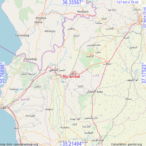
Muḩambal GPS coordinates[2]
35° 47' 14.46" North, 36° 28' 19.56" East
| Map corner | latitude | longitude |
|---|---|---|
| Upper-left | 36.35567°, | 35.76898° |
| Center: | 35.78735°, | 36.4721° |
| Lower-right: | 35.21494°, | 37.17523° |
| Map W x H: | 126.8×126.8 km | = 78.8×78.8mi |
| max Lat: | 37.17701° ⇑29.7% North |
| Muḩambal: | 35.78735° |
| min Lat: | ⇓70.3% South 32.39332° |
| min Long | Muḩambal | max Long |
| 35.75572° | 36.4721° | 42.14006° |
| W 42%⇐ | ⇒58% E |
Elevation
Elevation of Muḩambal is 370 m = 1214 ft, and this is 159.1 m = 522 ft below average elevation for this country.
| Max E: |
1640 m = 5381 ft | 67.1% |
| Avg. | 529.1 m = 1736 ft | |
| Muḩambal | 370 m = 1214 ft | |
Min E: |
4 m = 13 ft | 32.9% |
See also: Syria elevation on elevation.city.
Geographical zone
Muḩambal is located in North temperate zone (between Tropic of Cancer and the Arctic Circle). Distance of this Northern Tropic circle is 1373.3 km =853.3 mi to South.| Distance of | km | miles | from Muḩambal |
|---|---|---|---|
| North Pole | 6027.9 | 3745.6 | to North |
| Arctic Circle | 3422 | 2126.3 | to North |
| Tropic Cancer | 1373.3 | 853.3 | to South |
| Equator | 3979.2 | 2472.6 | to South |


Nearby cities:
15 places around Muḩambal: (largest is in red/bold)
• Al Jānūdīyah
19.6 km =12.2 mi,  303°
303°
• Arīḩā
12.7 km =7.9 mi,  76°
76°
• Az Ziyārah
16.6 km =10.3 mi,  226°
226°
• Bdāmā
25 km =15.5 mi,  276°
276°
• Binnish
28.8 km =17.9 mi,  49°
49°
• Darkūsh
23.8 km =14.8 mi,  342°
342°
• Idlib
21.6 km =13.4 mi,  42°
42°
• Iḩsim
10.6 km =6.6 mi,  134°
134°
• Jisr ash Shughūr
14.1 km =8.8 mi, 282°
• Kafranbel
21 km =13 mi,  156°
156°
• Kinnsibbā
28.2 km =17.5 mi,  260°
260°
• Ma‘arrat an Nu‘mān
24.1 km =15 mi, 129°
• Ma‘arratmişrīn
30.7 km =19.1 mi, 35°
• Sarmīn
26.2 km =16.3 mi,  60°
60°
• Ḩīsh
30.8 km =19.1 mi,  149°
149°
Sources, notices
• [Note1] Compared only with cities in Syria existing in our database
• [Src1] Map data: © OpenStreetMap contributors (CC-BY-SA)
• [Src2] Other city data from geonames.org with taken over terms of usage.
• [Src3] Geographical zone / Annual Mean Temperature by Robert A. Rohde @ Wikipedia
