Phu Sing geodata
Phu Sing (Sisaket) is a seat of a second-order administrative division; located in Thailand in Asia/Bangkok (GMT+7) time zone. In our database, there are 331 cities with bigger population. Compared to other cities in Thailand, 59% of cities are located further ↑North; 91.9% of cities are located further ←West and 78.8% of cities have lower elevation than Phu Sing. Note1


Phu Sing GPS coordinates[2]
14° 32' 50.784" North, 104° 7' 54.012" East
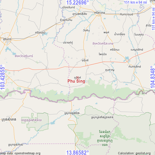
| Map corner | latitude | longitude |
|---|---|---|
| Upper-left | 15.22696°, | 103.42855° |
| Center: | 14.54744°, | 104.13167° |
| Lower-right: | 13.86582°, | 104.8348° |
| Map W x H: | 151.3×151.3 km | = 94×94mi |
| max Lat: | 20.43353° ⇑59% North |
| Phu Sing: | 14.54744° |
| min Lat: | ⇓41% South 5.77434° |
| min Long | Phu Sing | max Long |
| 97.93288° | 104.13167° | 105.49506° |
| W 91.9%⇐ | ⇒8.1% E |
Elevation
Elevation of Phu Sing is 193 m = 633 ft, and this is 67.5 m = 221 ft above average elevation for this country.
| Max E: |
1011 m = 3317 ft | 21.2% |
| Phu Sing | 193 m 633 ft | |
| Avg. | 125.5 m = 412 ft | |
Min E: |
1 m = 3 ft | 78.8% |
See also: Thailand elevation on elevation.city.
Geographical zone
Phu Sing is located in North Torrid zone (between Equator and Tropic of Cancer). Distance of this Northern Tropic circle is 988.4 km =614.2 mi to North.| Distance of | km | miles | from Phu Sing |
|---|---|---|---|
| North Pole | 8389.5 | 5213 | to North |
| Arctic Circle | 5783.7 | 3593.8 | to North |
| Tropic Cancer | 988.4 | 614.2 | to North |
| Equator | 1617.5 | 1005.1 | to South |


Nearby cities:
15 places around Phu Sing: (largest is in red/bold)
• Bua Chet
20.1 km =12.5 mi,  263°
263°
• Huai Thap Than
57.4 km =35.7 mi,  348°
348°
• Kantharalak
56.7 km =35.2 mi,  79°
79°
• Khu Khan
19.8 km =12.3 mi,  21°
21°
• Khun Han
32.5 km =20.2 mi, 76°
• Lamduan
53.4 km =33.2 mi,  291°
291°
• Phayu
48.9 km =30.4 mi,  34°
34°
• Phrai Bueng
33.4 km =20.8 mi,  48°
48°
• Prang Ku
35.8 km =22.2 mi,  343°
343°
• Samrong Thap
56.9 km =35.4 mi, 338°
• Sangkha
31.6 km =19.6 mi, 288°
• Si Khoraphum
56.9 km =35.4 mi,  320°
320°
• Si Narong
37 km =23 mi,  311°
311°
• Si Rattana
45.4 km =28.2 mi, 53°
• Wang Hin
45.8 km =28.5 mi,  13°
13°
Sources, notices
• [Note1] Compared only with cities in Thailand existing in our database
• [Src1] Map data: © OpenStreetMap contributors (CC-BY-SA)
• [Src2] Other city data from geonames.org with taken over terms of usage.
• [Src3] Geographical zone / Annual Mean Temperature by Robert A. Rohde @ Wikipedia
