Si Rattana geodata
Si Rattana (Sisaket) is a seat of a second-order administrative division; located in Thailand in Asia/Bangkok (GMT+7) time zone. In our database, there are 331 cities with bigger population. Compared to other cities in Thailand, 53.4% of cities are located further ↑North; 95% of cities are located further ←West and 58.1% of cities have lower elevation than Si Rattana. Note1


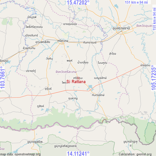
Si Rattana GPS coordinates[2]
14° 47' 35.808" North, 104° 28' 9.192" East
| Map corner | latitude | longitude |
|---|---|---|
| Upper-left | 15.47202°, | 103.7661° |
| Center: | 14.79328°, | 104.46922° |
| Lower-right: | 14.11241°, | 105.17235° |
| Map W x H: | 151.2×151.2 km | = 94×94mi |
| max Lat: | 20.43353° ⇑53.4% North |
| Si Rattana: | 14.79328° |
| min Lat: | ⇓46.6% South 5.77434° |
| min Long | Si Rattana | max Long |
| 97.93288° | 104.46922° | 105.49506° |
| W 95%⇐ | ⇒5% E |
Elevation
Elevation of Si Rattana is 144 m = 472 ft, and this is 18.5 m = 61 ft above average elevation for this country.
| Max E: |
1011 m = 3317 ft | 41.9% |
| Si Rattana | 144 m 472 ft | |
| Avg. | 125.5 m = 412 ft | |
Min E: |
1 m = 3 ft | 58.1% |
See also: Thailand elevation on elevation.city.
Geographical zone
Si Rattana is located in North Torrid zone (between Equator and Tropic of Cancer). Distance of this Northern Tropic circle is 961.1 km =597.2 mi to North.| Distance of | km | miles | from Si Rattana |
|---|---|---|---|
| North Pole | 8362.2 | 5196 | to North |
| Arctic Circle | 5756.3 | 3576.8 | to North |
| Tropic Cancer | 961.1 | 597.2 | to North |
| Equator | 1644.9 | 1022.1 | to South |


Nearby cities:
15 places around Si Rattana: (largest is in red/bold)
• Benchalak
21.6 km =13.4 mi,  89°
89°
• Kantharalak
25.8 km =16 mi,  131°
131°
• Kanthararom
36.2 km =22.5 mi,  17°
17°
• Khu Khan
30.4 km =18.9 mi,  253°
253°
• Khun Han
20.1 km =12.5 mi,  193°
193°
• Nam Kliang
15.6 km =9.7 mi, 17°
• Non Kho
30.7 km =19.1 mi,  63°
63°
• Phayu
15.3 km =9.5 mi,  326°
326°
• Phrai Bueng
12.5 km =7.8 mi, 246°
• Phu Sing
45.4 km =28.2 mi,  233°
233°
• Prang Ku
46.7 km =29 mi,  278°
278°
• Samrong
41.4 km =25.7 mi,  54°
54°
• Si Sa Ket
38.8 km =24.1 mi,  337°
337°
• Siao
21.6 km =13.4 mi, 89°
• Wang Hin
30.8 km =19.1 mi,  303°
303°
Sources, notices
• [Note1] Compared only with cities in Thailand existing in our database
• [Src1] Map data: © OpenStreetMap contributors (CC-BY-SA)
• [Src2] Other city data from geonames.org with taken over terms of usage.
• [Src3] Geographical zone / Annual Mean Temperature by Robert A. Rohde @ Wikipedia
