Hua Hin geodata
Hua Hin (Prachuap Khiri Khan) is a populated place; located in Thailand in Asia/Bangkok (GMT+7) time zone. With population of 50,456 people, there are 54 cities with bigger population in this country. Compared to other cities in Thailand, 80.3% of cities are located further ↑North; 73.9% of cities are located further →East and 85.9% of cities have higher elevation than Hua Hin. Note1


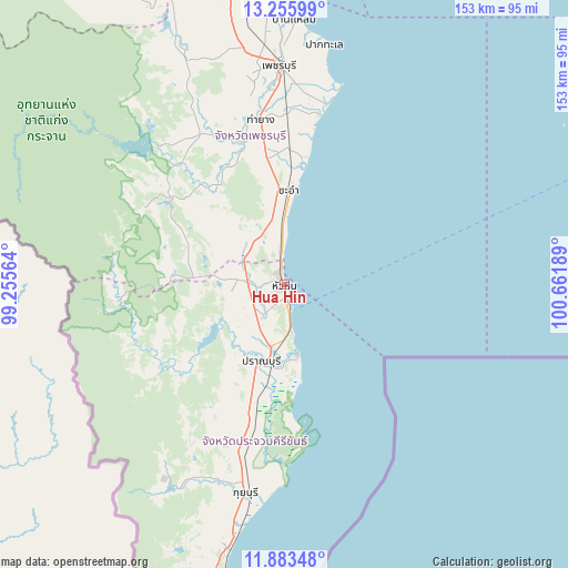
Hua Hin GPS coordinates[2]
12° 34' 14.34" North, 99° 57' 31.536" East
| Map corner | latitude | longitude |
|---|---|---|
| Upper-left | 13.25599°, | 99.25564° |
| Center: | 12.57065°, | 99.95876° |
| Lower-right: | 11.88348°, | 100.66189° |
| Map W x H: | 152.6×152.6 km | = 94.8×94.8mi |
| max Lat: | 20.43353° ⇑80.3% North |
| Hua Hin: | 12.57065° |
| min Lat: | ⇓19.7% South 5.77434° |
| min Long | Hua Hin | max Long |
| 97.93288° | 99.95876° | 105.49506° |
| W 26.1%⇐ | ⇒73.9% E |
Elevation
Elevation of Hua Hin is 10 m = 33 ft, and this is 115.5 m = 379 ft below average elevation for this country.
| Max E: |
1011 m = 3317 ft | 85.9% |
| Avg. | 125.5 m = 412 ft | |
| Hua Hin | 10 m = 33 ft | |
Min E: |
1 m = 3 ft | 14.1% |
See also: Hua Hin elevation on elevation.city.
Geographical zone
Hua Hin is located in North Torrid zone (between Equator and Tropic of Cancer). Distance of this Northern Tropic circle is 1208.2 km =750.7 mi to North.| Distance of | km | miles | from Hua Hin |
|---|---|---|---|
| North Pole | 8609.3 | 5349.6 | to North |
| Arctic Circle | 6003.4 | 3730.3 | to North |
| Tropic Cancer | 1208.2 | 750.7 | to North |
| Equator | 1397.7 | 868.5 | to South |


Nearby cities:
15 places around Hua Hin: (largest is in red/bold)
• Amphawa
94.9 km =59 mi,  359°
359°
• Ban Laem
70.5 km =43.8 mi,  1°
1°
• Ban Lat
53.7 km =33.4 mi, 355°
• Cha-am
25.5 km =15.8 mi, 1°
• Kaeng Krachan
50.4 km =31.3 mi,  318°
318°
• Khao Yoi
75.9 km =47.2 mi,  348°
348°
• Kui Buri
55.4 km =34.4 mi,  191°
191°
• Nong Ya Plong
71.7 km =44.6 mi,  336°
336°
• Pak Tho
90.1 km =56 mi, 351°
• Phetchaburi
60.2 km =37.4 mi, 358°
• Prachuap Khiri Khan
85.5 km =53.1 mi, 192°
• Pran Buri
21.6 km =13.4 mi,  196°
196°
• Sam Roi Yot
34.6 km =21.5 mi, 195°
• Samut Songkhram
94 km =58.4 mi, 2°
• Tha Yang
43.4 km =27 mi, 352°
Sources, notices
• [Note1] Compared only with cities in Thailand existing in our database
• [Src1] Map data: © OpenStreetMap contributors (CC-BY-SA)
• [Src2] Other city data from geonames.org with taken over terms of usage.
• [Src3] Geographical zone / Annual Mean Temperature by Robert A. Rohde @ Wikipedia
