Kaeng Krachan geodata
Kaeng Krachan (Phetchaburi) is a seat of a second-order administrative division; located in Thailand in Asia/Bangkok (GMT+7) time zone. In our database, there are 331 cities with bigger population. Compared to other cities in Thailand, 78.7% of cities are located further ↑North; 81.9% of cities are located further →East and 51.9% of cities have higher elevation than Kaeng Krachan. Note1


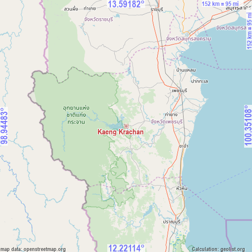
Kaeng Krachan GPS coordinates[2]
12° 54' 26.712" North, 99° 38' 52.62" East
| Map corner | latitude | longitude |
|---|---|---|
| Upper-left | 13.59182°, | 98.94483° |
| Center: | 12.90742°, | 99.64795° |
| Lower-right: | 12.22114°, | 100.35108° |
| Map W x H: | 152.4×152.4 km | = 94.7×94.7mi |
| max Lat: | 20.43353° ⇑78.7% North |
| Kaeng Krachan: | 12.90742° |
| min Lat: | ⇓21.3% South 5.77434° |
| min Long | Kaeng Krachan | max Long |
| 97.93288° | 99.64795° | 105.49506° |
| W 18.1%⇐ | ⇒81.9% E |
Elevation
Elevation of Kaeng Krachan is 75 m = 246 ft, and this is 50.5 m = 166 ft below average elevation for this country.
| Max E: |
1011 m = 3317 ft | 51.9% |
| Avg. | 125.5 m = 412 ft | |
| Kaeng Krachan | 75 m = 246 ft | |
Min E: |
1 m = 3 ft | 48.1% |
See also: Thailand elevation on elevation.city.
Geographical zone
Kaeng Krachan is located in North Torrid zone (between Equator and Tropic of Cancer). Distance of this Northern Tropic circle is 1170.7 km =727.4 mi to North.| Distance of | km | miles | from Kaeng Krachan |
|---|---|---|---|
| North Pole | 8571.9 | 5326.3 | to North |
| Arctic Circle | 5966 | 3707.1 | to North |
| Tropic Cancer | 1170.7 | 727.4 | to North |
| Equator | 1435.2 | 891.8 | to South |


Nearby cities:
15 places around Kaeng Krachan: (largest is in red/bold)
• Amphawa
66.5 km =41.3 mi,  30°
30°
• Ban Kha
63.6 km =39.5 mi,  336°
336°
• Ban Laem
48.8 km =30.3 mi,  47°
47°
• Ban Lat
33.3 km =20.7 mi,  61°
61°
• Bang Khon Thi
70 km =43.5 mi, 26°
• Cha-am
36.6 km =22.7 mi,  109°
109°
• Hua Hin
50.4 km =31.3 mi,  138°
138°
• Khao Yoi
41.6 km =25.8 mi, 27°
• Nong Ya Plong
28.9 km =18 mi,  10°
10°
• Pak Tho
55.7 km =34.6 mi,  21°
21°
• Phetchaburi
39.4 km =24.5 mi, 54°
• Pran Buri
64.3 km =40 mi,  154°
154°
• Samut Songkhram
68.2 km =42.4 mi, 34°
• Tha Yang
28.5 km =17.7 mi,  78°
78°
• Wat Phleng
66 km =41 mi, 23°
Sources, notices
• [Note1] Compared only with cities in Thailand existing in our database
• [Src1] Map data: © OpenStreetMap contributors (CC-BY-SA)
• [Src2] Other city data from geonames.org with taken over terms of usage.
• [Src3] Geographical zone / Annual Mean Temperature by Robert A. Rohde @ Wikipedia
