Tha Yang geodata
Tha Yang (Phetchaburi) is a populated place; located in Thailand in Asia/Bangkok (GMT+7) time zone. With population of 42,602 people, there are 72 cities with bigger population in this country. Compared to other cities in Thailand, 78.3% of cities are located further ↑North; 75.6% of cities are located further →East and 83.5% of cities have higher elevation than Tha Yang. Note1


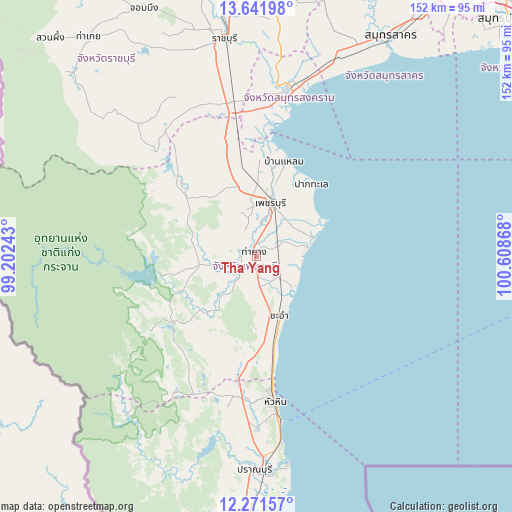
Tha Yang GPS coordinates[2]
12° 57' 27.792" North, 99° 54' 19.98" East
| Map corner | latitude | longitude |
|---|---|---|
| Upper-left | 13.64198°, | 99.20243° |
| Center: | 12.95772°, | 99.90555° |
| Lower-right: | 12.27157°, | 100.60868° |
| Map W x H: | 152.4×152.4 km | = 94.7×94.7mi |
| max Lat: | 20.43353° ⇑78.3% North |
| Tha Yang: | 12.95772° |
| min Lat: | ⇓21.7% South 5.77434° |
| min Long | Tha Yang | max Long |
| 97.93288° | 99.90555° | 105.49506° |
| W 24.4%⇐ | ⇒75.6% E |
Elevation
Elevation of Tha Yang is 11 m = 36 ft, and this is 114.5 m = 376 ft below average elevation for this country.
| Max E: |
1011 m = 3317 ft | 83.5% |
| Avg. | 125.5 m = 412 ft | |
| Tha Yang | 11 m = 36 ft | |
Min E: |
1 m = 3 ft | 16.5% |
See also: Tha Yang elevation on elevation.city.
Geographical zone
Tha Yang is located in North Torrid zone (between Equator and Tropic of Cancer). Distance of this Northern Tropic circle is 1165.2 km =724 mi to North.| Distance of | km | miles | from Tha Yang |
|---|---|---|---|
| North Pole | 8566.3 | 5322.9 | to North |
| Arctic Circle | 5960.4 | 3703.6 | to North |
| Tropic Cancer | 1165.2 | 724 | to North |
| Equator | 1440.8 | 895.3 | to South |


Nearby cities:
15 places around Tha Yang: (largest is in red/bold)
• Amphawa
52.2 km =32.4 mi,  6°
6°
• Ban Laem
28.6 km =17.8 mi,  16°
16°
• Ban Lat
10.5 km =6.5 mi, 6°
• Bang Khon Thi
57 km =35.4 mi,  3°
3°
• Cha-am
18.7 km =11.6 mi,  159°
159°
• Damnoen Saduak
62.6 km =38.9 mi, 4°
• Hua Hin
43.4 km =27 mi,  172°
172°
• Kaeng Krachan
28.5 km =17.7 mi,  258°
258°
• Khao Yoi
32.6 km =20.3 mi,  344°
344°
• Nong Ya Plong
32.1 km =19.9 mi,  315°
315°
• Pak Tho
46.7 km =29 mi,  351°
351°
• Phetchaburi
17.7 km =11 mi, 13°
• Pran Buri
63.7 km =39.6 mi,  180°
180°
• Samut Songkhram
51.9 km =32.2 mi, 11°
• Wat Phleng
55.2 km =34.3 mi,  357°
357°
Sources, notices
• [Note1] Compared only with cities in Thailand existing in our database
• [Src1] Map data: © OpenStreetMap contributors (CC-BY-SA)
• [Src2] Other city data from geonames.org with taken over terms of usage.
• [Src3] Geographical zone / Annual Mean Temperature by Robert A. Rohde @ Wikipedia
