Sam Roi Yot geodata
Sam Roi Yot (Prachuap Khiri Khan) is a seat of a second-order administrative division; located in Thailand in Asia/Bangkok (GMT+7) time zone. With population of 19,709 people, there are 160 cities with bigger population in this country. Compared to other cities in Thailand, 80.9% of cities are located further ↑North; 76.8% of cities are located further →East and 72.9% of cities have higher elevation than Sam Roi Yot. Note1


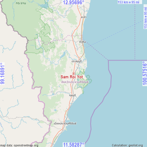
Sam Roi Yot GPS coordinates[2]
12° 16' 14.916" North, 99° 52' 19.308" East
| Map corner | latitude | longitude |
|---|---|---|
| Upper-left | 12.95696°, | 99.16891° |
| Center: | 12.27081°, | 99.87203° |
| Lower-right: | 11.58287°, | 100.57516° |
| Map W x H: | 152.8×152.8 km | = 94.9×94.9mi |
| max Lat: | 20.43353° ⇑80.9% North |
| Sam Roi Yot: | 12.27081° |
| min Lat: | ⇓19.1% South 5.77434° |
| min Long | Sam Roi Yot | max Long |
| 97.93288° | 99.87203° | 105.49506° |
| W 23.2%⇐ | ⇒76.8% E |
Elevation
Elevation of Sam Roi Yot is 17 m = 56 ft, and this is 108.5 m = 356 ft below average elevation for this country.
| Max E: |
1011 m = 3317 ft | 72.9% |
| Avg. | 125.5 m = 412 ft | |
| Sam Roi Yot | 17 m = 56 ft | |
Min E: |
1 m = 3 ft | 27.1% |
See also: Thailand elevation on elevation.city.
Geographical zone
Sam Roi Yot is located in North Torrid zone (between Equator and Tropic of Cancer). Distance of this Northern Tropic circle is 1241.5 km =771.4 mi to North.| Distance of | km | miles | from Sam Roi Yot |
|---|---|---|---|
| North Pole | 8642.7 | 5370.3 | to North |
| Arctic Circle | 6036.8 | 3751.1 | to North |
| Tropic Cancer | 1241.5 | 771.4 | to North |
| Equator | 1364.4 | 847.8 | to South |


Nearby cities:
15 places around Sam Roi Yot: (largest is in red/bold)
• Ban Laem
104.5 km =64.9 mi,  6°
6°
• Ban Lat
86.9 km =54 mi,  3°
3°
• Cha-am
59.7 km =37.1 mi, 9°
• Hua Hin
34.6 km =21.5 mi,  15°
15°
• Kaeng Krachan
74.8 km =46.5 mi,  341°
341°
• Khao Yoi
107.9 km =67 mi,  357°
357°
• Kui Buri
21 km =13 mi,  185°
185°
• Nong Ya Plong
101 km =62.8 mi,  349°
349°
• Pak Tho
122.6 km =76.2 mi, 358°
• Phetchaburi
93.9 km =58.3 mi, 4°
• Prachuap Khiri Khan
50.9 km =31.6 mi, 190°
• Pran Buri
13.1 km =8.1 mi, 14°
• Sattahip
120 km =74.6 mi,  68°
68°
• Tha Yang
76.5 km =47.5 mi, 2°
• Thap Sakae
90 km =55.9 mi,  197°
197°
Sources, notices
• [Note1] Compared only with cities in Thailand existing in our database
• [Src1] Map data: © OpenStreetMap contributors (CC-BY-SA)
• [Src2] Other city data from geonames.org with taken over terms of usage.
• [Src3] Geographical zone / Annual Mean Temperature by Robert A. Rohde @ Wikipedia
