Yaring geodata
Yaring (Pattani) is a seat of a second-order administrative division; located in Thailand in Asia/Bangkok (GMT+7) time zone. With population of 31,111 people, there are 105 cities with bigger population in this country. Compared to other cities in Thailand, 95.5% of cities are located further ↑North; 59.9% of cities are located further ←West and 96.7% of cities have higher elevation than Yaring. Note1


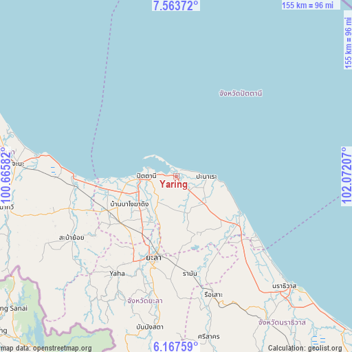
Yaring GPS coordinates[2]
6° 51' 58.212" North, 101° 22' 8.184" East
| Map corner | latitude | longitude |
|---|---|---|
| Upper-left | 7.56372°, | 100.66582° |
| Center: | 6.86617°, | 101.36894° |
| Lower-right: | 6.16759°, | 102.07207° |
| Map W x H: | 155.2×155.2 km | = 96.4×96.4mi |
| max Lat: | 20.43353° ⇑95.5% North |
| Yaring: | 6.86617° |
| min Lat: | ⇓4.5% South 5.77434° |
| min Long | Yaring | max Long |
| 97.93288° | 101.36894° | 105.49506° |
| W 59.9%⇐ | ⇒40.1% E |
Elevation
Elevation of Yaring is 6 m = 20 ft, and this is 119.5 m = 392 ft below average elevation for this country.
| Max E: |
1011 m = 3317 ft | 96.7% |
| Avg. | 125.5 m = 412 ft | |
| Yaring | 6 m = 20 ft | |
Min E: |
1 m = 3 ft | 3.3% |
See also: Thailand elevation on elevation.city.
Geographical zone
Yaring is located in North Torrid zone (between Equator and Tropic of Cancer). Distance of Equator is 763.4 km =474.4 mi to South.| Distance of | km | miles | from Yaring |
|---|---|---|---|
| North Pole | 9243.6 | 5743.7 | to North |
| Arctic Circle | 6637.7 | 4124.5 | to North |
| Tropic Cancer | 1842.5 | 1144.9 | to North |
| Equator | 763.4 | 474.4 | to South |


Nearby cities:
15 places around Yaring: (largest is in red/bold)
• Bacho
49.8 km =30.9 mi,  141°
141°
• Kapho
38.7 km =24 mi,  151°
151°
• Khok Pho
33.7 km =20.9 mi,  243°
243°
• Mae Lan
26.9 km =16.7 mi,  212°
212°
• Mai Kaen
43.5 km =27 mi,  130°
130°
• Mayo
17 km =10.6 mi,  164°
164°
• Nong Chik
21.2 km =13.2 mi,  263°
263°
• Panare
13.5 km =8.4 mi,  92°
92°
• Pattani
13.1 km =8.1 mi,  270°
270°
• Raman
43.5 km =27 mi,  171°
171°
• Sai Buri
32.9 km =20.4 mi,  123°
123°
• Thepha
44.9 km =27.9 mi, 264°
• Thung Yang Daeng
28.3 km =17.6 mi, 167°
• Yala
37.5 km =23.3 mi,  194°
194°
• Yarang
14.5 km =9 mi,  215°
215°
Sources, notices
• [Note1] Compared only with cities in Thailand existing in our database
• [Src1] Map data: © OpenStreetMap contributors (CC-BY-SA)
• [Src2] Other city data from geonames.org with taken over terms of usage.
• [Src3] Geographical zone / Annual Mean Temperature by Robert A. Rohde @ Wikipedia
