Thepha geodata
Thepha (Songkhla) is a seat of a second-order administrative division; located in Thailand in Asia/Bangkok (GMT+7) time zone. In our database, there are 331 cities with bigger population. Compared to other cities in Thailand, 95.9% of cities are located further ↑North; 53.6% of cities are located further ←West and 94.4% of cities have higher elevation than Thepha. Note1


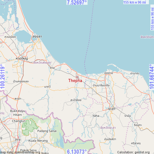
Thepha GPS coordinates[2]
6° 49' 45.696" North, 100° 57' 51.516" East
| Map corner | latitude | longitude |
|---|---|---|
| Upper-left | 7.52697°, | 100.26119° |
| Center: | 6.82936°, | 100.96431° |
| Lower-right: | 6.13073°, | 101.66744° |
| Map W x H: | 155.2×155.3 km | = 96.4×96.5mi |
| max Lat: | 20.43353° ⇑95.9% North |
| Thepha: | 6.82936° |
| min Lat: | ⇓4.1% South 5.77434° |
| min Long | Thepha | max Long |
| 97.93288° | 100.96431° | 105.49506° |
| W 53.6%⇐ | ⇒46.4% E |
Elevation
Elevation of Thepha is 7 m = 23 ft, and this is 118.5 m = 389 ft below average elevation for this country.
| Max E: |
1011 m = 3317 ft | 94.4% |
| Avg. | 125.5 m = 412 ft | |
| Thepha | 7 m = 23 ft | |
Min E: |
1 m = 3 ft | 5.6% |
See also: Thailand elevation on elevation.city.
Geographical zone
Thepha is located in North Torrid zone (between Equator and Tropic of Cancer). Distance of Equator is 759.4 km =471.9 mi to South.| Distance of | km | miles | from Thepha |
|---|---|---|---|
| North Pole | 9247.7 | 5746.3 | to North |
| Arctic Circle | 6641.8 | 4127 | to North |
| Tropic Cancer | 1846.6 | 1147.4 | to North |
| Equator | 759.4 | 471.9 | to South |


Nearby cities:
15 places around Thepha: (largest is in red/bold)
• Chana
26.5 km =16.5 mi,  291°
291°
• Ka Bang
47.1 km =29.3 mi,  167°
167°
• Khok Pho
18.2 km =11.3 mi,  127°
127°
• Mae Lan
35.7 km =22.2 mi,  121°
121°
• Mayo
50.7 km =31.5 mi,  104°
104°
• Na Mom
47.2 km =29.3 mi, 287°
• Na Thawi
31.7 km =19.7 mi,  252°
252°
• Nong Chik
23.6 km =14.7 mi,  86°
86°
• Pattani
31.8 km =19.8 mi,  82°
82°
• Saba Yoi
23.6 km =14.7 mi,  183°
183°
• Thung Yang Daeng
56.2 km =34.9 mi,  114°
114°
• Yaha
43.1 km =26.8 mi,  154°
154°
• Yala
47.5 km =29.5 mi, 132°
• Yarang
37.1 km =23.1 mi, 102°
• Yaring
44.9 km =27.9 mi, 84°
Sources, notices
• [Note1] Compared only with cities in Thailand existing in our database
• [Src1] Map data: © OpenStreetMap contributors (CC-BY-SA)
• [Src2] Other city data from geonames.org with taken over terms of usage.
• [Src3] Geographical zone / Annual Mean Temperature by Robert A. Rohde @ Wikipedia
