Wat Sing geodata
Wat Sing (Chai Nat) is a seat of a second-order administrative division; located in Thailand in Asia/Bangkok (GMT+7) time zone. In our database, there are 331 cities with bigger population. Compared to other cities in Thailand, 53.9% of cities are located further ↓South; 71.2% of cities are located further →East and 69.2% of cities have higher elevation than Wat Sing. Note1


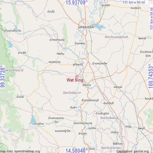
Wat Sing GPS coordinates[2]
15° 15' 35.532" North, 100° 2' 25.44" East
| Map corner | latitude | longitude |
|---|---|---|
| Upper-left | 15.93709°, | 99.33728° |
| Center: | 15.25987°, | 100.0404° |
| Lower-right: | 14.58046°, | 100.74353° |
| Map W x H: | 150.8×150.8 km | = 93.7×93.7mi |
| max Lat: | 20.43353° ⇑46.1% North |
| Wat Sing: | 15.25987° |
| min Lat: | ⇓53.9% South 5.77434° |
| min Long | Wat Sing | max Long |
| 97.93288° | 100.0404° | 105.49506° |
| W 28.8%⇐ | ⇒71.2% E |
Elevation
Elevation of Wat Sing is 24 m = 79 ft, and this is 101.5 m = 333 ft below average elevation for this country.
| Max E: |
1011 m = 3317 ft | 69.2% |
| Avg. | 125.5 m = 412 ft | |
| Wat Sing | 24 m = 79 ft | |
Min E: |
1 m = 3 ft | 30.8% |
See also: Thailand elevation on elevation.city.
Geographical zone
Wat Sing is located in North Torrid zone (between Equator and Tropic of Cancer). Distance of this Northern Tropic circle is 909.2 km =565 mi to North.| Distance of | km | miles | from Wat Sing |
|---|---|---|---|
| North Pole | 8310.3 | 5163.8 | to North |
| Arctic Circle | 5704.4 | 3544.5 | to North |
| Tropic Cancer | 909.2 | 565 | to North |
| Equator | 1696.7 | 1054.3 | to South |


Nearby cities:
15 places around Wat Sing: (largest is in red/bold)
• Chai Nat
12.1 km =7.5 mi,  132°
132°
• Hankha
31.1 km =19.3 mi,  185°
185°
• Krok Phra
33.1 km =20.6 mi,  5°
5°
• Manorom
7.2 km =4.5 mi,  39°
39°
• Noen Kham
36.1 km =22.4 mi,  197°
197°
• Nong Chang
25.9 km =16.1 mi,  304°
304°
• Nong Kha Yang
16.6 km =10.3 mi,  314°
314°
• Nong Mamong
18.8 km =11.7 mi,  275°
275°
• Phayuha Khiri
24 km =14.9 mi,  25°
25°
• Sankhaburi
27 km =16.8 mi,  151°
151°
• Sapphaya
25.1 km =15.6 mi,  120°
120°
• Sawang Arom
40.8 km =25.4 mi,  331°
331°
• Takhli
32.5 km =20.2 mi,  89°
89°
• Thap Than
27.4 km =17 mi,  324°
324°
• Uthai Thani
13.4 km =8.3 mi,  352°
352°
Sources, notices
• [Note1] Compared only with cities in Thailand existing in our database
• [Src1] Map data: © OpenStreetMap contributors (CC-BY-SA)
• [Src2] Other city data from geonames.org with taken over terms of usage.
• [Src3] Geographical zone / Annual Mean Temperature by Robert A. Rohde @ Wikipedia
