Krok Phra geodata
Krok Phra (Nakhon Sawan) is a seat of a second-order administrative division; located in Thailand in Asia/Bangkok (GMT+7) time zone. In our database, there are 331 cities with bigger population. Compared to other cities in Thailand, 59% of cities are located further ↓South; 70.6% of cities are located further →East and 68.1% of cities have higher elevation than Krok Phra. Note1


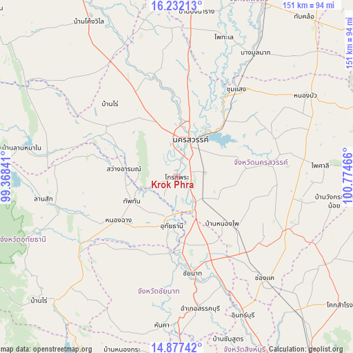
Krok Phra GPS coordinates[2]
15° 33' 21.204" North, 100° 4' 17.508" East
| Map corner | latitude | longitude |
|---|---|---|
| Upper-left | 16.23213°, | 99.36841° |
| Center: | 15.55589°, | 100.07153° |
| Lower-right: | 14.87742°, | 100.77466° |
| Map W x H: | 150.6×150.6 km | = 93.6×93.6mi |
| max Lat: | 20.43353° ⇑41% North |
| Krok Phra: | 15.55589° |
| min Lat: | ⇓59% South 5.77434° |
| min Long | Krok Phra | max Long |
| 97.93288° | 100.07153° | 105.49506° |
| W 29.4%⇐ | ⇒70.6% E |
Elevation
Elevation of Krok Phra is 26 m = 85 ft, and this is 99.5 m = 326 ft below average elevation for this country.
| Max E: |
1011 m = 3317 ft | 68.1% |
| Avg. | 125.5 m = 412 ft | |
| Krok Phra | 26 m = 85 ft | |
Min E: |
1 m = 3 ft | 31.9% |
See also: Thailand elevation on elevation.city.
Geographical zone
Krok Phra is located in North Torrid zone (between Equator and Tropic of Cancer). Distance of this Northern Tropic circle is 876.3 km =544.5 mi to North.| Distance of | km | miles | from Krok Phra |
|---|---|---|---|
| North Pole | 8277.4 | 5143.3 | to North |
| Arctic Circle | 5671.5 | 3524.1 | to North |
| Tropic Cancer | 876.3 | 544.5 | to North |
| Equator | 1729.7 | 1074.8 | to South |


Nearby cities:
15 places around Krok Phra: (largest is in red/bold)
• Banphot Phisai
43.3 km =26.9 mi,  347°
347°
• Chai Nat
41.5 km =25.8 mi,  172°
172°
• Kao Liao
32.8 km =20.4 mi,  1°
1°
• Lat Yao
37.2 km =23.1 mi,  305°
305°
• Manorom
27.4 km =17 mi,  177°
177°
• Nakhon Sawan
18 km =11.2 mi,  23°
23°
• Nong Chang
30.7 km =19.1 mi,  233°
233°
• Nong Kha Yang
26.2 km =16.3 mi,  215°
215°
• Nong Mamong
38.1 km =23.7 mi, 215°
• Phayuha Khiri
13.1 km =8.1 mi,  148°
148°
• Sawang Arom
22.8 km =14.2 mi,  277°
277°
• Takhli
43.7 km =27.2 mi,  138°
138°
• Thap Than
22 km =13.7 mi,  241°
241°
• Uthai Thani
20.3 km =12.6 mi,  194°
194°
• Wat Sing
33.1 km =20.6 mi, 185°
Sources, notices
• [Note1] Compared only with cities in Thailand existing in our database
• [Src1] Map data: © OpenStreetMap contributors (CC-BY-SA)
• [Src2] Other city data from geonames.org with taken over terms of usage.
• [Src3] Geographical zone / Annual Mean Temperature by Robert A. Rohde @ Wikipedia
