Chai Nat geodata
Chai Nat is a seat of a first-order administrative division; located in Thailand in Asia/Bangkok (GMT+7) time zone. With population of 15,469 people, there are 212 cities with bigger population in this country. Compared to other cities in Thailand, 52.4% of cities are located further ↓South; 68.6% of cities are located further →East and 68.1% of cities have higher elevation than Chai Nat. Note1


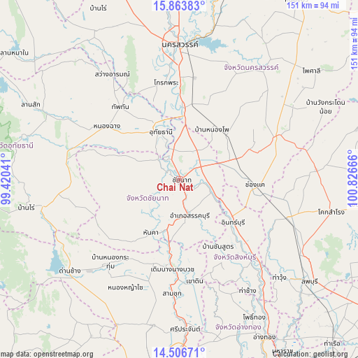
Chai Nat GPS coordinates[2]
15° 11' 10.896" North, 100° 7' 24.708" East
| Map corner | latitude | longitude |
|---|---|---|
| Upper-left | 15.86383°, | 99.42041° |
| Center: | 15.18636°, | 100.12353° |
| Lower-right: | 14.50671°, | 100.82666° |
| Map W x H: | 150.9×150.9 km | = 93.8×93.8mi |
| max Lat: | 20.43353° ⇑47.6% North |
| Chai Nat: | 15.18636° |
| min Lat: | ⇓52.4% South 5.77434° |
| min Long | Chai Nat | max Long |
| 97.93288° | 100.12353° | 105.49506° |
| W 31.4%⇐ | ⇒68.6% E |
Elevation
Elevation of Chai Nat is 26 m = 85 ft, and this is 99.5 m = 326 ft below average elevation for this country.
| Max E: |
1011 m = 3317 ft | 68.1% |
| Avg. | 125.5 m = 412 ft | |
| Chai Nat | 26 m = 85 ft | |
Min E: |
1 m = 3 ft | 31.9% |
See also: Thailand elevation on elevation.city.
Geographical zone
Chai Nat is located in North Torrid zone (between Equator and Tropic of Cancer). Distance of this Northern Tropic circle is 917.4 km =570 mi to North.| Distance of | km | miles | from Chai Nat |
|---|---|---|---|
| North Pole | 8318.5 | 5168.9 | to North |
| Arctic Circle | 5712.6 | 3549.6 | to North |
| Tropic Cancer | 917.4 | 570 | to North |
| Equator | 1688.6 | 1049.2 | to South |


Nearby cities:
15 places around Chai Nat: (largest is in red/bold)
• Bang Racham
38.8 km =24.1 mi,  147°
147°
• Doem Bang Nang Buat
37 km =23 mi,  184°
184°
• Hankha
25.6 km =15.9 mi,  207°
207°
• In Buri
29.5 km =18.3 mi,  132°
132°
• Manorom
14.4 km =8.9 mi,  342°
342°
• Noen Kham
32.9 km =20.4 mi,  217°
217°
• Nong Chang
37.9 km =23.5 mi,  307°
307°
• Nong Kha Yang
28.7 km =17.8 mi, 313°
• Nong Mamong
29.3 km =18.2 mi,  289°
289°
• Phayuha Khiri
29.9 km =18.6 mi,  2°
2°
• Sankhaburi
16 km =9.9 mi,  165°
165°
• Sapphaya
13.5 km =8.4 mi,  109°
109°
• Takhli
25.1 km =15.6 mi,  70°
70°
• Uthai Thani
23.9 km =14.9 mi,  333°
333°
• Wat Sing
12.1 km =7.5 mi, 312°
Sources, notices
• [Note1] Compared only with cities in Thailand existing in our database
• [Src1] Map data: © OpenStreetMap contributors (CC-BY-SA)
• [Src2] Other city data from geonames.org with taken over terms of usage.
• [Src3] Geographical zone / Annual Mean Temperature by Robert A. Rohde @ Wikipedia
