Uthumphon Phisai geodata
Uthumphon Phisai (Sisaket) is a seat of a second-order administrative division; located in Thailand in Asia/Bangkok (GMT+7) time zone. In our database, there are 331 cities with bigger population. Compared to other cities in Thailand, 51.7% of cities are located further ↓South; 92% of cities are located further ←West and 57.4% of cities have lower elevation than Uthumphon Phisai. Note1


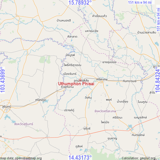
Uthumphon Phisai GPS coordinates[2]
15° 6' 41.796" North, 104° 8' 24.396" East
| Map corner | latitude | longitude |
|---|---|---|
| Upper-left | 15.78932°, | 103.43699° |
| Center: | 15.11161°, | 104.14011° |
| Lower-right: | 14.43173°, | 104.84324° |
| Map W x H: | 150.9×151 km | = 93.8×93.8mi |
| max Lat: | 20.43353° ⇑48.3% North |
| Uthumphon Phisai: | 15.11161° |
| min Lat: | ⇓51.7% South 5.77434° |
| min Long | Uthumphon Phisa | max Long |
| 97.93288° | 104.14011° | 105.49506° |
| W 92%⇐ | ⇒8% E |
Elevation
Elevation of Uthumphon Phisai is 142 m = 466 ft, and this is 16.5 m = 54 ft above average elevation for this country.
| Max E: |
1011 m = 3317 ft | 42.6% |
| Uthumphon Phisai | 142 m 466 ft | |
| Avg. | 125.5 m = 412 ft | |
Min E: |
1 m = 3 ft | 57.4% |
See also: Thailand elevation on elevation.city.
Geographical zone
Uthumphon Phisai is located in North Torrid zone (between Equator and Tropic of Cancer). Distance of this Northern Tropic circle is 925.7 km =575.2 mi to North.| Distance of | km | miles | from Uthumphon Phisai |
|---|---|---|---|
| North Pole | 8326.8 | 5174 | to North |
| Arctic Circle | 5720.9 | 3554.8 | to North |
| Tropic Cancer | 925.7 | 575.2 | to North |
| Equator | 1680.3 | 1044.1 | to South |


Nearby cities:
15 places around Uthumphon Phisai: (largest is in red/bold)
• Bueng Bun
26.4 km =16.4 mi,  337°
337°
• Huai Thap Than
13.7 km =8.5 mi,  241°
241°
• Kho Wang
36.7 km =22.8 mi,  38°
38°
• Mueang Chan
12.4 km =7.7 mi,  295°
295°
• Non Narai
28.1 km =17.5 mi, 299°
• Phayu
35.2 km =21.9 mi,  129°
129°
• Pho Si Suwan
14.7 km =9.1 mi,  332°
332°
• Prang Ku
30.3 km =18.8 mi,  200°
200°
• Rasi Salai
26 km =16.2 mi,  3°
3°
• Rattanaburi
38.8 km =24.1 mi,  306°
306°
• Samrong Thap
24 km =14.9 mi,  245°
245°
• Si Sa Ket
20.3 km =12.6 mi,  88°
88°
• Sila Lat
40.7 km =25.3 mi,  349°
349°
• Wang Hin
20.7 km =12.9 mi,  151°
151°
• Yang Chum Noi
32.5 km =20.2 mi,  58°
58°
Sources, notices
• [Note1] Compared only with cities in Thailand existing in our database
• [Src1] Map data: © OpenStreetMap contributors (CC-BY-SA)
• [Src2] Other city data from geonames.org with taken over terms of usage.
• [Src3] Geographical zone / Annual Mean Temperature by Robert A. Rohde @ Wikipedia
