Non Narai geodata
Non Narai (Surin) is a seat of a second-order administrative division; located in Thailand in Asia/Bangkok (GMT+7) time zone. In our database, there are 331 cities with bigger population. Compared to other cities in Thailand, 53.4% of cities are located further ↓South; 89.3% of cities are located further ←West and 55.7% of cities have lower elevation than Non Narai. Note1


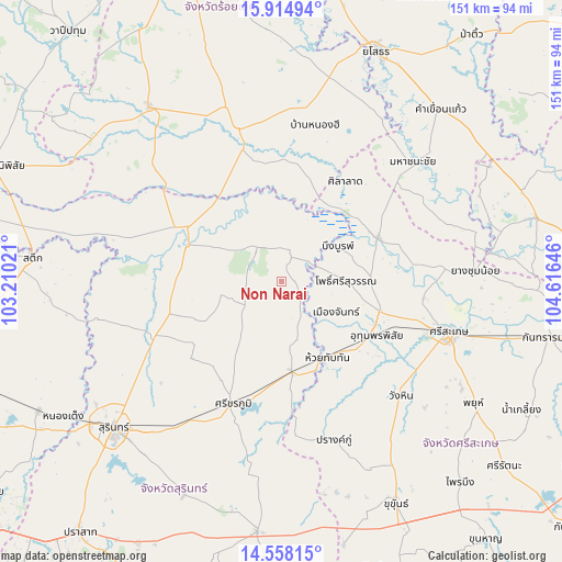
Non Narai GPS coordinates[2]
15° 14' 15.504" North, 103° 54' 47.988" East
| Map corner | latitude | longitude |
|---|---|---|
| Upper-left | 15.91494°, | 103.21021° |
| Center: | 15.23764°, | 103.91333° |
| Lower-right: | 14.55815°, | 104.61646° |
| Map W x H: | 150.9×150.9 km | = 93.8×93.8mi |
| max Lat: | 20.43353° ⇑46.6% North |
| Non Narai: | 15.23764° |
| min Lat: | ⇓53.4% South 5.77434° |
| min Long | Non Narai | max Long |
| 97.93288° | 103.91333° | 105.49506° |
| W 89.3%⇐ | ⇒10.7% E |
Elevation
Elevation of Non Narai is 138 m = 453 ft, and this is 12.5 m = 41 ft above average elevation for this country.
| Max E: |
1011 m = 3317 ft | 44.3% |
| Non Narai | 138 m 453 ft | |
| Avg. | 125.5 m = 412 ft | |
Min E: |
1 m = 3 ft | 55.7% |
See also: Thailand elevation on elevation.city.
Geographical zone
Non Narai is located in North Torrid zone (between Equator and Tropic of Cancer). Distance of this Northern Tropic circle is 911.7 km =566.5 mi to North.| Distance of | km | miles | from Non Narai |
|---|---|---|---|
| North Pole | 8312.8 | 5165.3 | to North |
| Arctic Circle | 5706.9 | 3546.1 | to North |
| Tropic Cancer | 911.7 | 566.5 | to North |
| Equator | 1694.3 | 1052.8 | to South |


Nearby cities:
15 places around Non Narai: (largest is in red/bold)
• Bueng Bun
17.5 km =10.9 mi,  53°
53°
• Chom Phra
35.4 km =22 mi,  247°
247°
• Huai Thap Than
23.9 km =14.9 mi,  149°
149°
• Mueang Chan
15.8 km =9.8 mi,  123°
123°
• Nong Hi
42.4 km =26.3 mi,  11°
11°
• Pho Si Suwan
17.6 km =10.9 mi,  93°
93°
• Phon Sai
29.2 km =18.1 mi,  17°
17°
• Rasi Salai
28.5 km =17.7 mi,  65°
65°
• Rattanaburi
11.3 km =7 mi,  322°
322°
• Samrong Thap
24 km =14.9 mi,  174°
174°
• Sanom
16.8 km =10.4 mi,  256°
256°
• Si Khoraphum
34.9 km =21.7 mi,  200°
200°
• Sila Lat
31.1 km =19.3 mi,  33°
33°
• Tha Tum
27.1 km =16.8 mi,  289°
289°
• Uthumphon Phisai
28.1 km =17.5 mi, 119°
Sources, notices
• [Note1] Compared only with cities in Thailand existing in our database
• [Src1] Map data: © OpenStreetMap contributors (CC-BY-SA)
• [Src2] Other city data from geonames.org with taken over terms of usage.
• [Src3] Geographical zone / Annual Mean Temperature by Robert A. Rohde @ Wikipedia
